
Canada 150: Inuvik
Our road trip up the Dempster led us, eventually, to Inuvik. Located 200 km north of the Arctic Circle, Inuvik was built in the 1950s in its present location in the Mackenzie River delta to function as the region’s administrative centre.
Inuvik is the northernmost point of Canada that I’ve ever been to. Until this year, it was also the northernmost point in Canada that you could drive to in the summer. In the winter, the Dempster Highway continues north to Tuktoyaktuk for another 194 km along an ice road formed on the channels of the Mackenzie River delta and the Arctic Ocean. This ice road was only open during the winters, but is being replaced by a new all-season road scheduled to be finished by the end of next summer.
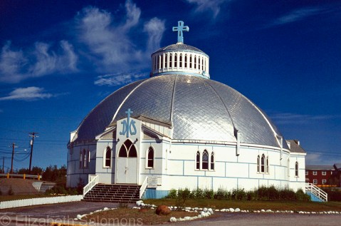
Our Lady of Victory Parish, or the Igloo Church as it is often called, is the community’s Catholic church. It was designed by Brother Maurice Larocque, a missionary from Quebec who spent his entire ministry working in the North. Before he became a priest, he was a carpenter, and he used his skills to design a church that reflected the people who would worship in it. The church was built in the shape of an igloo to be able to deal with the shifting permafrost it stands on.
The Igloo Church is the most photographed building in Inuvik. Naturally, I had to take a photo, too.
Canada 150: Tsiigehtchic

This photo is of Tsiigehtchic, which is where the Mackenzie River meets the Arctic Red River, and where the Dempster Highway crosses the Mackenzie River. Vehicles cross by ferry in the summer. In the winter, there is an ice crossing.
Tsiigehtchic is the Gwich’in word for “mouth of the iron river.” Iron river (Tsiigehnjik) is their name for the Arctic Red River.
Nagwichoonjik, or “river flowing through a big country,” is what the Gwich’in call the Mackenzie River. The Dene call it Deh Cho, which means “big river.” And its Inuvialuktun name is Kuukpak, which means “great river.”
In case there is any doubt, the Mackenzie is a big river. At 4241 km long, it’s the largest and longest river in Canada, and the second largest and longest in North America. (Only the Mississippi is longer.) The Mackenzie River’s watershed covers one-fifth of Canada’s land mass.
The river got its English name from Alexander Mackenzie, who followed its length to the Arctic Ocean in 1789. He hoped the river would empty into the Pacific Ocean. When he realized it did not, he is said to have named it Disappointment River.
That’s an awful lot of names for one river. Whatever you call it, it’s worth crossing.
