
Cruising Season
Yup, it’s that time of year. The cruising season is upon us here in Vancouver.
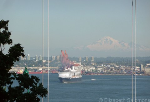
A cruise ship sails out of Vancouver’s Burrard Inlet, with Washington’s Mount Baker in the distance.
The first ship arrived on April 18, but the season didn’t really kick into high gear until this week with the arrival and departure of 13 ships in eight days. From now until the end of September, between five and seven ships will dock in Vancouver every week, with each ship staying just long enough to offload its passengers and get the next bunch safely on board.

It’s rush hour — three cruise ships leave Canada Place within an hour of each other.
A total of 17 cruise ships will be based in Vancouver this season, setting sail each week for Alaska. Their route takes them through the Inside Passage along BC’s coast. Later this afternoon, I’ll be boarding one of those ships, but my destination is nowhere near as exotic as Alaska. I’m headed south — to Seattle.

Holland America has five ships based in Vancouver this season.
Through My Lens: Grand Central Terminal

For my 100th post: a photo of the main concourse of Grand Central Terminal in New York City, because this magnificent building is celebrating its 100th birthday today. The doors to the station ― which New Yorkers refer to as “Grand Central Station” or simply “Grand Central” ― were first opened to the public at 12:01 am on February 2, 1913.
Staten Island Ferry
Looking at TV and Internet images of natural disasters is always tough, but never more so when you’re familiar with the region or you know people in the disaster zone. Such was the case for me this week. Hurricane Sandy ran right over the cities I visited last summer and I nervously waited to hear from people near and dear to me in Baltimore and New York City who both, thankfully, made it through to the other side of Sandy unscathed.
I was talking about the hurricane with a colleague on Tuesday morning, and I tried to explain to her the geography of New York City as she doesn’t know the city. That conversation made me think of the video I shot last summer from the Staten Island Ferry.
The Staten Island Ferry runs between the boroughs of Manhattan and Staten Island. It’s a free service, and I love ferry boats, so I hopped on one morning to get a good look at Lower Manhattan and the Statue of Liberty from the water. It’s about a 30-minute ride for the five-mile trip. On the Staten Island side, most tourists ― as did I ― turn around and hop right back on the ferry for the return trip to Manhattan.
The ferry connects with the subway on the Manhattan side. As you’ll see in the video, it was a bit of a blustery day when I took my ferry ride. After I disembarked, I stood at the subway entrance for a few minutes, debating whether to head Uptown on the train (much faster) or the bus (much better view). The subway station where I stood that morning (South Ferry – Whitehall Street) had water up to its ceiling on Monday night, and as far as I understand is still flooded.
I decided on the bus just as the skies opened up. It turned out to be a bit of a wild ride because of the weather. At each stop, New Yorkers poured onto the bus holding newspapers over their heads, and through the open bus doors I could see water gushing down the street.
But back to the video. The reason I wanted to show it to you is so you can see just how low Lower Manhattan is. Much of the southern tip of the island is, in fact, reclaimed land. (The Dutch were the first Europeans to settle on Manhattan, and they know a thing or two about reclaiming land.) You can see Battery Park in the video ― it’s those trees to the left. That’s the park I so enjoyed walking through last summer, and it too was badly flooded on Monday night. It’s not hard to imagine how much damage the record-breaking 13-foot storm surge could cause in this city. The East River is to the right, spanned by the Brooklyn Bridge, and the river to the far left is the Hudson.
Both ferry terminals of the Staten Island Ferry were damaged by Hurricane Sandy. As of this writing, partial service is expected to resume on Friday.
Toronto Street Cars

Nothing says “Toronto” to me as much as its iconic red street cars.
For several years, I rode the 504 King car every day on my way to and from work, but when I first moved to Toronto, it took me a while to figure out where and how I was expected to board the street cars. The only street cars I was familiar with were the trams in Amsterdam. In that city, there are raised concrete platforms along the tram tracks where you stand to wait for the tram.
Although some street-car stops in Toronto have platforms similar to those in Amsterdam, most stops are marked with a small sign attached to a light pole. The signs are easy to miss if you don’t know where to look. You wait on the sidewalk beneath the sign, just as you would wait for a bus at a bus stop. The street car pulls up, traffic in the lane between the street car and sidewalk stops, and you step out into the road to board the street car.
Street cars have been operating continuously in Toronto since 1861, and Toronto’s system is the largest in North America in terms of ridership, number of cars, and track length. Its eleven lines, most of which crisscross downtown and all of which connect with the subway, have a daily ridership of over a quarter of a million people.
Hanging Out in Solo
While my sister and her husband are busy eating, drinking, and loving their way around Italy, I’ve been on house-sitting duty. House sitting, I’m discovering, is an awful lot like home exchanging: it gives me a chance to enjoy the perks of someone else’s home for a while, and the opportunity to explore a new neighbourhood. The only difference between this round of house sitting and my previous home exchanges is that, if I need something from home, I can easily go get it.
The perks this time are pretty good. I have an enormous south-facing backyard all to myself, with a covered patio, a Rolls-Royce of barbecues, and an herb garden. Beyond that, there’s a back 40 filled with bushes dripping with almost-ripe blackberries. The herb garden has to be watered daily, as does a forest of small trees belonging to my brother-in-law. And then there are the six cats (two of them my own) who need to be fed and watered twice a day. I feel like I’m playing farmer, what with all these animals, crops, and chores, but hey, it’s summertime, and it’s pretty heavenly.
The neighbourhood, on the other hand? Not so heavenly. I’m in North Burnaby, in an area some developers are starting to call Solo ― that’s SOuth of LOugheed. (Go ahead, laugh. I did.) The subdivision where I am temporarily lodged is sandwiched between two highways: Lougheed (with the elevated SkyTrain running above it) and the Trans-Canada. That means I’m listening to the constant white noise of freeway traffic to the south, and the intermittent whirr of the SkyTrain to the north.
North Burnaby is not that attractive, in other words. It’s one mall after another, one industrial park after another, one arterial road after another. I loathe the whole car culture that is necessary here; I know it’s no different from any other North American suburb, but it’s what I hate most about suburbia and why I choose to live downtown. The other day I used a drive-through ATM for the first time in my life, and felt strangely defeated by doing so.
However, spend enough time in a neighbourhood and eventually, somewhere, somehow, you begin to discover its treasures. Burnaby has a few that are simply delightful, which I’ll write about in another post. For now, I will remind you (my faithful readers) and myself that the intent of this blog is to take a second look at our surroundings ― whether beautiful or mundane. And I’ll leave you with a photo of some marvellous engineering. After all, there is beauty in that, too, right?

SkyTrain tracks snaking their way east above Lougheed Highway
Through My Lens: BC Ferries

Nothing says “summer” to me like taking a ferry ride on BC Ferries. I spent last weekend island hopping as I visited friends on Salt Spring Island and Vancouver Island. This photo was taken from Galiano Island during another weekend of island hopping some months ago.
Engine No. 374
There is an amazing piece of Canadian history not far from where I live.
It’s Engine No. 374. Engine No. 374 is the locomotive that pulled the first transcontinental train across Canada ― from the Atlantic all the way to the Pacific ― arriving in Vancouver on May 23, 1887.
I have to admit I get a little thrill every time I walk by Engine No. 374. It’s the history geek in me.
British Columbia is a part of Canada because of the railway. The young colony joined Confederation in 1871 after Sir John A. Macdonald, our esteemed first prime minister, promised to build a railway to connect it to the rest of Canada. That was quite a promise; even more amazing was that Sir John A. said it would be done within ten years.
It took fourteen, but it got done ― an incredible engineering feat for a country not yet two decades old. There was a political scandal, which brought down the government, and there was a rebellion. But eventually, on November 7, 1885, the two ends of the railway met somewhere in the middle of BC’s Interior.
All that is now part of Canada’s national myth. Myths are great, and necessary, to a national identity. And that is why, when I walk by Engine No. 374, I get a little thrill.
I also love the romanticism of trains. Great stories begin on trains. It used to be that new Canadians began their lives in Canada by crossing the country by train. My ancestors did. And I, many years ago, travelled across Canada by train because I’d decided I needed to do it at least once in order to truly understand this vast and varied country of ours. When I finally disembarked in Quebec City after five days of coach travel from Vancouver, the conductor remarked that I had become part of the furniture.
The most surreal moment of that trip, however, was when I and the fellow who sat down across from me after boarding the train in Sudbury recognized each other, and it took us to North Bay to figure out where from. We finally put it together that we had met a couple of years earlier at the youth hostel in Baden-Baden, Germany, and then bumped into each other a few weeks later in the Venice train station, and yet again a few weeks after that in the middle of some demonstration in the centre of Athens. (Yes, the Greeks were already demonstrating back in the 1980s.) We were both criss-crossing Europe by train at the time. Great stories begin on trains.
Engine No. 374 was built by Canadian Pacific Railway in Montreal in 1886. It was completely rebuilt in 1914, and then continued in active use until 1945. After sitting at Kitsilano Beach for almost forty years, it was restored and put on display for Expo 86. Today it stands in a glass pavilion that is part of the Roundhouse Community Centre in Yaletown.
When I was taking the photos for this post, the volunteer working at the pavilion wouldn’t leave my elbow. As I knelt down to get a shot, he told me that once a year, on the Sunday closest to May 23, Engine No. 374 is taken out of its glass pavilion and moved into Turntable Plaza.
Now that’s a thrill this history geek won’t want to miss.
