
Amsterdam’s Canals
Today’s reminder of Amsterdam came from an umbrella I saw someone carrying: it was bright red with the three white Xs on black of the Amsterdam flag running along four of its ribs. Funnily enough, as much rain as there was in Amsterdam this past summer, I never once saw one of those umbrellas over there.
But I did here, in Vancouver’s West End.
And yes, that means our rainy season has officially started. To keep myself cheerful during these dark and dreary months, I’m going to finish off the series of posts about my summer travels that I haven’t gotten around to writing.
Staring with this one about Amsterdam’s canals.

Amsterdam has a lot of canals. A lot. And a lot of bridges. Far more canals and bridges than Venice, which is why some people call Amsterdam “Venice of the North.” But Amsterdam looks nothing like Venice. And when an Italian-American friend of mine once asked me what people did with their bikes in Amsterdam, I looked at her, puzzled.
“What do you mean ‘do with them’? They ride them, of course.”
“But how do you ride a bike in a city with so many canals?”
Oh, right. She’s Italian. She’s thinking of Venice. I told her how Amsterdam’s canals are all lined with streets — one on each side — and the streets had plenty of room for bikes. That’s also when I told her about my first-ever visit to Venice.
It was a holiday weekend in three countries (Italy, Yugoslavia, and Austria) and the youth hostel was completely full. The guy at the check-in counter told my friend and me that our best option was to try the convent down the street. He gave us precise directions: exit the hostel, turn left, and walk three bridges down.
“Do we walk over the bridges or beside them?” I asked in all seriousness. He looked at me like I was an idiot and asked, dryly, “If you don’t walk over the bridge, how will you cross the canal?”
Smart-ass, I thought, but as soon as my friend and I headed down the street, I saw what he meant. In Venice, there are no streets beside the canals and there is no way to get across a canal except by — you guessed it — walking over a bridge.
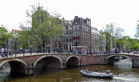
In Amsterdam, it’s entirely possible to walk the length of a canal without crossing it once. Where it intersects with another canal, you have the option of making a sharp turn left or right to start walking alongside that other canal. And at each one of those intersections, the bridges (there some 1500 of them in Amsterdam) go both over a canal while also going beside the other, intersecting, canal.
Last summer, I decided to get to know Amsterdam’s canals better and the best way to do that is to walk them. Off I went: down the Prinsengracht one day, back home along the Keizergracht, and then the next morning all the way along the Herengracht and back along the Singel.
The Singel is Amsterdam’s innermost canal, built way back in the Middle Ages and initially the city’s moat. In the seventeenth century, the city planners decided to add three more concentric canals parallel to the Singel. This expansion made Amsterdam four times larger than it was before and was desperately needed — by the end of the seventeenth century, the city’s population was four times greater than it had been when they first began building the new canals. (This was the Dutch Golden Age, when the Netherlands was the world’s maritime power and Amsterdam one of the world’s largest cities.)
The new canals all ended at the Amstel River, and were designed for both defense and transport and, yes, to manage all that water. (Remember, Amsterdam is below sea level.) The entire area became known as the Grachtengordel (canal belt) and was declared a UNESCO heritage site in 2010.
The first canal past the Singel is the Herengracht (Gentlemen’s Canal). It’s named after the men who governed Amsterdam during the Dutch Golden Age, many of whom lived along the Herengracht. One stretch, called the Golden Bend, was developed a little later than the rest of the canal, and its mansions were built on double-wide lots. Many of these are now consulates, banks, or museums.

The next canal is the Keizergracht (Emperor’s Canal). It’s the widest of the three canals and was named after the Holy Roman Emperor, Maximilian I.
And finally, there’s the Prinsengracht (Prince’s Canal), named after the Prince of Orange. It is Amsterdam’s longest canal and is the dividing line between the Grachtengordel and the Jordaan.
These three major canals are connected to each other by dozens of smaller canals. The Leidsegracht is the widest of these and used to be the main transportation connection between Amsterdam and Leiden (hence its name). The Reguliersgracht (regulator’s canal) is probably the most photographed canal in all of Amsterdam. It is also where, if you are at water level, you can look through seven bridges at one time — a fact you learn when you take your canal boat tour. And the Brouwersgracht (brewer’s canal) way down at the other end of the Grachtengordel is where a lot of breweries were located (hence its name).

Eventually, my Italian-American friend spent a weekend in Amsterdam with me and saw for herself how different Amsterdam’s canals are from Venice’s. And shortly after our arrival in Amsterdam last July, I told my nieces the story of how I expected Venice’s canals to be just like Amsterdam’s. My youngest niece has since told me, now that she has seen Amsterdam’s canals, that she wants to go to Venice to see for herself how the Italian canals compare.
That’s what it’s all about folks: cross-cultural awareness and understanding.
About those bikes: just because the streets alongside the canals are wide enough to bike on doesn’t mean that bikes don’t end up in the canal. It’s been said that Amsterdam’s canals are one-third mud, one-third water, and one-third bikes and that more than 15,000 bikes are pulled out of the canals every year.

Trackbacks / Pingbacks