
Through My Lens: Steveston Boats

Steveston is a fishing village at the mouth of the South Arm of the Fraser River. It’s been there awhile, since the 1880s, and has a history that is equally fascinating and tragic. Nowadays, it’s the largest commercial fishing harbour in Canada.
Here’s a photo I took last night.
River Otter
In my last post, I mentioned that one of Lost Lagoon’s four remaining Mute Swans had been killed by a river otter. These furry fellows can be found in Lost Lagoon, but also like to hang out wherever there’s fish. Sometimes, that brings them to the beach in English Bay
Which is where I took this photo.
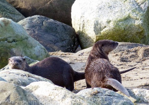
River otters are not the same as sea otters, so don’t be confused by the fact that they can be found near the ocean. They go wherever the fish are, so if that means they hang out on the beach, so be it.
Sea otters, I’ve been told, are not found in the Salish Sea. They live on the west coast of Vancouver Island or along BC’s northern coast. One clue, apparently, to tell the two types of otters apart: river otters almost never swim on their backs, while sea otters often do.
Mute Swan
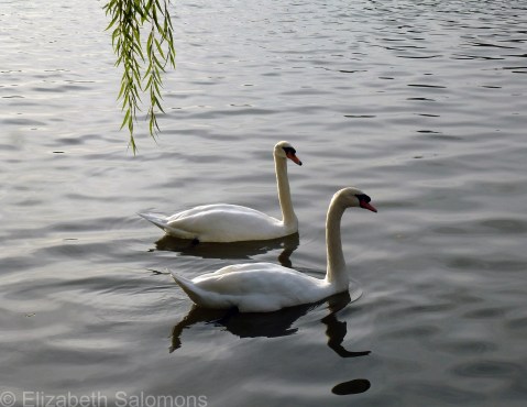
Indulge me, if you will, as I post yet another set of bird photos. This is the Mute Swan, which, until last August, was a common sight at Stanley Park’s Lost Lagoon.
The reason Lost Lagoon no longer has any resident swans is that the last three swans were officially retired and now live at an animal sanctuary somewhere in the Fraser Valley. The move came after a fourth swan was killed by river otters. The swans are geriatric, and it was decided they should live out their remaining years without the threat of predators.

The Mute Swan is not native to North American, but you see them everywhere on this continent, mainly in city parks. Back in the 1960s, there were at least 70 of them living at Lost Lagoon. These days, however, the caretakers at Stanley Park are keen to ensure that native species thrive over invasive species. (I could tell you about the blackberries, but that’s a whole other post.)
Don’t worry, though. This isn’t the last you’ll see of swans in Stanley Park. Because the park is on the Pacific Flyway, you have a good chance of seeing either the Trumpeter Swan or the Tundra Swan as they pass through when they migrate — and they are far more likely to stop in if there are no more of the territorial Mute Swans.
But, invasive species or not, aren’t they magnificent creatures?
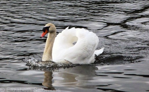
One last note: The Mute Swan is the national bird of Denmark. Does that surprise you? It sure did me. I would have guessed England, but apparently that country is still trying in the process of choosing a national bird. As is Canada.
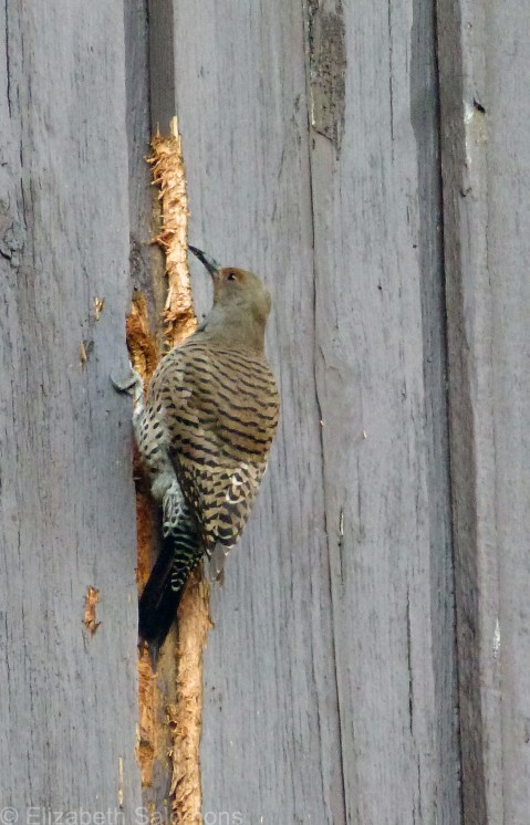
Northern Flicker
Today is the first day of Vancouver Bird Week and to make it a little more interesting, the city is taking a vote on which of four birds should be Vancouver’s Official Bird.
Vancouver has had a City Bird for three years now. The Northwestern Crow was selected in 2014. In 2015, the honour went to the Black-capped Chickadee and in 2016 to the Peregrine Falcon. But this year is different: the honour of City Bird will become permanent.
Oh, the pressure!
None of the previous City Birds are considered eligible. Bummer, as my favourite Vancouver bird is the Black-capped Chickadee. Also not eligible are any birds that are a city, provincial/state, or national bird elsewhere. (That kinda narrows it down. Another choice of mine would have been the Bald Eagle, of which Vancouver has plenty.) Two final stipulations are that the potential City Bird cannot be viewed negatively by any cultural groups (?), and cannot be commonly found outside of the Pacific Northwest. Vancouver’s City Bird has to be uniquely West Coast.
So, which birds made the Final Four??
Those would be the Spotted Towhee (photo here), Anna’s Hummingbird (photo here), the Varied Thrush (sadly, no photo), and the Northern Flicker (below).
Which one did I vote for?
Now that would be telling.
But may the Best Bird win.
Anna’s Hummingbird
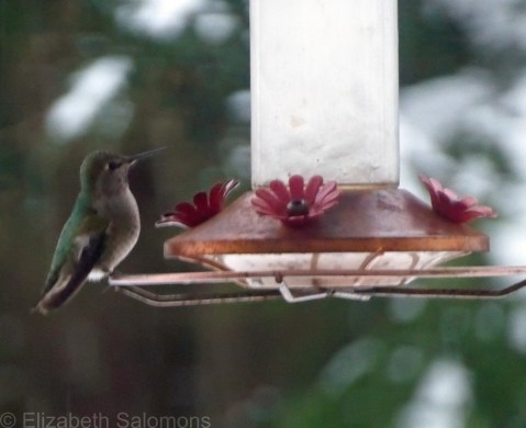
I took this photo of an Anna’s Hummingbird a few weeks ago during our last snowstorm. I was housebound during that storm because I was hanging out in Solo. If you look closely, you can see that the water in the feeder is almost frozen solid. I’m sure that hummingbird was as confused as I was by the cold weather.
Why am I posting this photo today? Because this morning I spent nearly an hour watching big fat snowflakes fall from the sky.
C’mon. It’s almost March. More snow??
Vancouver has had twice as much snow this winter as Edmonton where it’s winter seven months of the year. (I can say that because I grew up in Edmonton. I know winter. Er … I used to know winter.)
Anna’s Hummingbirds do not migrate south from Vancouver for the winter, thanks to the proliferation of backyard feeders like this one. I still can’t get my head around the fact that hummingbirds are here year-round.
I just hope all that hovering they do kept those tiny birds warm this winter.
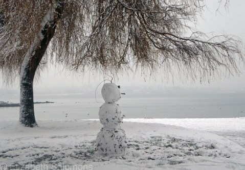
Snow Day in Vancouver
Wait, what?
Yup. Snow Day in Vancouver. Normally in February, I’m posting photos of crocuses. Or gloating about how spring is right around the corner.
Not this year. We’ve had one of the snowiest, coldest winters I can remember, and I’ve lived here off and on for a good chunk of my life. This winter we had a white Christmas for the first time in almost a decade, and for the first time ever in my memory, the snow stuck around for an entire month. It arrived in early December and it didn’t leave until after New Year’s when the temperature finally warmed up and the rain washed it all away.
I expected we would have a normal winter going forward. But no.
We got another record dump of the white stuff this past weekend. Because we don’t usually get snow, what most Canadians take for granted, like snow plows and snow tires, we do not have enough of. And without plowed roads or snow tires, you are not going to get very far. Ever been in an articulated bus that was sliding backwards down a hill? I have. It was not pleasant.
So today was a snow day for a lot of people in this town.
And there is more snow in the forecast.
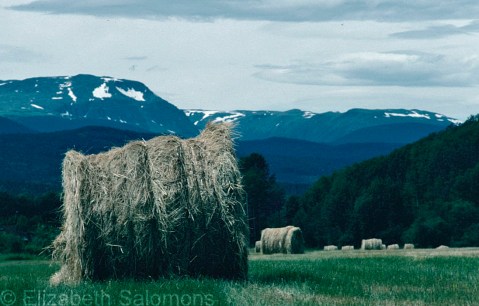
Canada 150: Somewhere Near McBride
Update: My friend tells me this field is along Barrett Station Road near Houston. The mountains are the Telkwa Range. Oops! I was only off by some 500 kilometres.
On the Travel Bucket List of every Canadian should be two trips: (1) a road trip across Canada and (2) the same by train. I’ve almost completed both.
The train trip I’ll save for another post; the road trip was done in several legs, several years apart. (Since Canada is such a vast country, it is my opinion that it is not cheating if you break these trips down into manageable chunks.)
Leg one of my cross-Canada road trip was completed the summer I moved from Vancouver to Toronto. I packed as many of my meager belongings as I could fit into the back of my Honda Civic hatchback, kissed my parents good-bye, got into my car and headed … north.
North? Why not? (What’s a 24-hour detour when you’re about to spend days driving across Canada?)
Yes, I started my trek east by driving north to the Bulkley Valley where some friends of mine were living, and it was only after that visit that I pointed my trusty little car east towards the Rockies.
I took this photo somewhere along the Yellowhead. My foggy memory tells me it was near McBride, but, truthfully, it could have been anywhere between Houston and Jasper. The hay bales are what made me pull over to take a photo.
I love hay bales.
Canada 150: Kamloops Lake
It’s not often that I travel to Alberta by car, but when I do, I am always struck by the diverse landscape of the province where I live. In just one day’s travel, you drive through the flat delta of the Fraser River, head up the narrow gorges of the Fraser Canyon or the steep incline of the Coquihalla Pass (depending on which route you take), then it’s through the grasslands and forests of the Interior before crossing a mountain range or three.
This photo, which I took from the Trans-Canada Highway during the summer of 2009, is of Kamloops Lake. I love the landscape around Kamloops. It’s got mountains, it’s got valleys, it’s got deserts.
And look. It’s got trains, too.

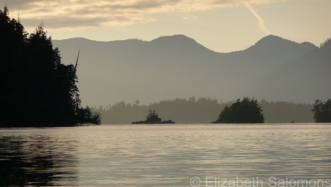
Canada 150: Broken Group Islands
Happy New Year, everyone! I think we’re all glad to see the backside of 2016, but the big question for today is: what will 2017 bring us?
For Canadians, 2017 is going to be one long party. Yup, it’s our sesquicentennial (enriching your word power, I am). All that fancy word means is this: we Canadians are celebrating our nation’s 150th birthday in 2017. Canada 150 is what we are calling this little party.
Canada came into existence, formally, on July 1, 1867, when the British Parliament passed the British North America Act of 1867 (commonly referred to as Confederation). But although our official birthday isn’t until July 1, the party is already well underway. Even Lonely Planet has taken note. It has Canada as the # 1 choice in its list of places to visit in 2017. It’s even posted a free PDF chapter of how to plan your trip. You can download it here.
The Canadian government is encouraging that spirit of travel and adventure by giving anyone and everyone (that’s you, me, and the entire world — everyone is invited!) free admission to any of its Parks Canada locations. Which are quite a few: 47 national parks, 171 national historic sites, and four marine conservation areas. You can order your 2017 Discovery Pass here.
As for my part in celebrating Canada’s sesquicentennial, I’ve decided to take you all on a cross-Canada photographic tour. I’ve been blessed by the opportunity to live in three different provinces of this great nation, and I have travelled from coast to coast to coast through much of the rest of the country. And so, at least once a month throughout 2017 (maybe more often if I get really excited about this), I will post a photo from a different province or territory of Canada.
To begin: the Broken Group Islands. Accessible only by boat, these islands are located on the west coast of Vancouver Island in Pacific Rim National Park Reserve. (Your 2017 Discovery Pass will get you there!) I’ve camped and kayaked in the Broken Group Islands twice already and hope to go back many more times as they are, quite simply, one of the most spectacular places I’ve ever been to. Anywhere.
The Broken Group Islands are also the westernmost point of Canada that I’ve been to. I took this photo in August 2008 from the beach on Gibraltar Island where my friends and I were camped.
Stanley Park Windstorm
Ten years ago today, a massive windstorm devastated Stanley Park. Hurricane-force winds off English Bay levelled 41 hectares of forest, about 10,000 trees in all, some of which were more than 500 years old. It was the most violent windstorm to hit Stanley Park in 40 years.
Although it was overwhelming to see the devastation, the forest was long overdue for a regeneration. The wide open spaces changed the look of parts of the park and increased the diversity of both plant life and animals. Woodpeckers, for example, are now thriving. More than 15,000 trees and shrubs were planted by park staff and volunteers. I was walking near Prospect Point recently and it struck me how tall those young trees are already.
I was out of town on December 15, 2006, but I remember taking a walk through the park on Christmas Day — as much as it was possible to walk through the park since every trail was blocked by fallen trees — with my mouth open wide in shock. The seawall was also extensively damaged and remained closed for some 18 months until the repairs could be finished and the cliff tops above the seawall stabilized.
This photo is of a tree that came down near the Georgia Street entrance to Stanley Park. It lies near where it fell, trimmed of its foliage, and has been left as a memorial to that storm. It is now a popular photo stop for tourists, who I am sure have no idea why it is lying there.

