Canada 150: Tr’ochëk

Here is one last photo from North of 60. This is fireweed, the official flower of Yukon. It takes its name from the fact that it is one of the first plants to grow after a forest fire.
I took this photo at Tr’ochëk, a former settlement of the Tr’ondëk Hwëch’in First Nation. It’s also known as Moosehide. Located about 5 km down the Yukon River from Dawson City, the settlement was abandoned in the 1960s after its only school was closed. Today, it is an important gathering place and a seasonal fishing camp for the Tr’ondëk Hwëch’in First Nation.
Canada 150: Inuvik
Our road trip up the Dempster led us, eventually, to Inuvik. Located 200 km north of the Arctic Circle, Inuvik was built in the 1950s in its present location in the Mackenzie River delta to function as the region’s administrative centre.
Inuvik is the northernmost point of Canada that I’ve ever been to. Until this year, it was also the northernmost point in Canada that you could drive to in the summer. In the winter, the Dempster Highway continues north to Tuktoyaktuk for another 194 km along an ice road formed on the channels of the Mackenzie River delta and the Arctic Ocean. This ice road was only open during the winters, but is being replaced by a new all-season road scheduled to be finished by the end of next summer.
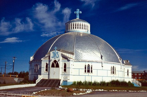
Our Lady of Victory Parish, or the Igloo Church as it is often called, is the community’s Catholic church. It was designed by Brother Maurice Larocque, a missionary from Quebec who spent his entire ministry working in the North. Before he became a priest, he was a carpenter, and he used his skills to design a church that reflected the people who would worship in it. The church was built in the shape of an igloo to be able to deal with the shifting permafrost it stands on.
The Igloo Church is the most photographed building in Inuvik. Naturally, I had to take a photo, too.
Canada 150: Tsiigehtchic

This photo is of Tsiigehtchic, which is where the Mackenzie River meets the Arctic Red River, and where the Dempster Highway crosses the Mackenzie River. Vehicles cross by ferry in the summer. In the winter, there is an ice crossing.
Tsiigehtchic is the Gwich’in word for “mouth of the iron river.” Iron river (Tsiigehnjik) is their name for the Arctic Red River.
Nagwichoonjik, or “river flowing through a big country,” is what the Gwich’in call the Mackenzie River. The Dene call it Deh Cho, which means “big river.” And its Inuvialuktun name is Kuukpak, which means “great river.”
In case there is any doubt, the Mackenzie is a big river. At 4241 km long, it’s the largest and longest river in Canada, and the second largest and longest in North America. (Only the Mississippi is longer.) The Mackenzie River’s watershed covers one-fifth of Canada’s land mass.
The river got its English name from Alexander Mackenzie, who followed its length to the Arctic Ocean in 1789. He hoped the river would empty into the Pacific Ocean. When he realized it did not, he is said to have named it Disappointment River.
That’s an awful lot of names for one river. Whatever you call it, it’s worth crossing.
Anna’s Hummingbird
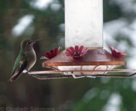
I took this photo of an Anna’s Hummingbird a few weeks ago during our last snowstorm. I was housebound during that storm because I was hanging out in Solo. If you look closely, you can see that the water in the feeder is almost frozen solid. I’m sure that hummingbird was as confused as I was by the cold weather.
Why am I posting this photo today? Because this morning I spent nearly an hour watching big fat snowflakes fall from the sky.
C’mon. It’s almost March. More snow??
Vancouver has had twice as much snow this winter as Edmonton where it’s winter seven months of the year. (I can say that because I grew up in Edmonton. I know winter. Er … I used to know winter.)
Anna’s Hummingbirds do not migrate south from Vancouver for the winter, thanks to the proliferation of backyard feeders like this one. I still can’t get my head around the fact that hummingbirds are here year-round.
I just hope all that hovering they do kept those tiny birds warm this winter.
Canada 150: Dempster Highway

If you’ve already driven some 2500 kilometres to get from Edmonton to Dawson City, what’s another 800 klicks to go to Inuvik for lunch?
That’s what we thought.
The above photo is of the Dempster Highway, the only road from Dawson to Inuvik. It’s also the only all-weather road in Canada to cross the Arctic Circle. Because of the permafrost, it is surfaced with gravel. When we returned to Dawson City, we were surprised to learn it was rare not to pop a tire or two driving the Dempster Highway to Inuvik and back.
I guess we got lucky.
There’s one place to stop for service along the Dempster Highway and that’s at Eagle Plains, which is the halfway point between Dawson and Inuvik. We filled up with gas there, but camped overnight closer to Inuvik simply by pitching our tents on the shoulder of the highway.
It wasn’t like there was much traffic to keep us awake.
Canada 150: Dawson City
On leg three of my cross-Canada road trip, I drove from Edmonton to Dawson City with a friend. And it was on this trip that I learned a valuable lesson about travelling that has stuck with me ever since.
Always (always, always!!) do your research before you leave home.
My friend and I, both living in Toronto at the time, decided to drive to Dawson City from Edmonton instead of Whitehorse because we both had people we wanted to visit in Edmonton. We flew separately, a few days apart, and I booked us a rental car at the Edmonton International Airport where I would meet her.
I still remember the exact moment the sinking feeling formed in the pit of my stomach. Spread out on the floor of my brother’s living room was a road map that I had been using to calculate how long it would take us to drive to Dawson City. (This was back in the olden days, folks, long before Google Maps.) I started at it in disbelief. Turns out that, even after flying across four provinces, my friend and I were only halfway to the Yukon from Toronto. We had a 36-hour drive ahead of us.
Oops.
But you know what? It was a stunning road trip. We spent our first night with an aunt of mine who lived on a farm in northern Alberta, stopped for a minute the next day in Dawson Creek, BC, to take our obligatory photos at Mile 0 of the Alaska Highway, and camped that night near the BC–Yukon border where we soaked our weary bodies in Canada’s second-largest hot springs at Liard River.
On our third day, we pushed on until we finally arrived at Dawson City around 1 a.m. My sister, who was working in Dawson for the summer, was up and waiting for us.
I was running on adrenalin by that point and nowhere near ready for bed, so my sister took me to the top of Midnight Dome for my first view of the town. It was early July and at that hour it was dusky, but light enough to understand why they call it Land of the Midnight Sun. I took this photo of the view of Dawson City and the Yukon River from Midnight Dome the next day.
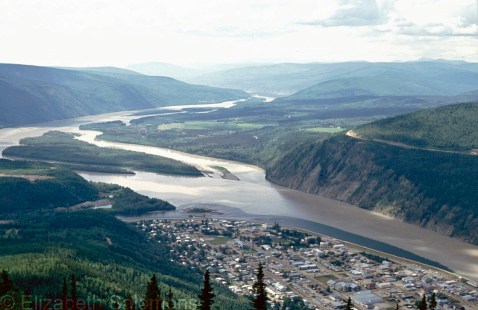
Dawson City was the epicentre of the Klondike Gold Rush. After gold was discovered in 1896, an estimated 100,000 people poured into the area, hoping to make their fortune. Almost overnight, Dawson became the largest city west of Winnipeg and north of Seattle.
It was over as quickly as it started. The miners moved on to Alaska after gold was discovered there in 1899. Gold mining still goes on in Dawson today, but most of the town’s economy is based on tourism, which celebrates its Klondike past.
The Klondike Gold Rush transformed all of Western Canada, however. The population of Vancouver doubled and Edmonton’s tripled in those few short years as both cities served as gateways to the Klondike.
Just as Edmonton did for my friend and I.
Snow Day in Vancouver
Wait, what?
Yup. Snow Day in Vancouver. Normally in February, I’m posting photos of crocuses. Or gloating about how spring is right around the corner.
Not this year. We’ve had one of the snowiest, coldest winters I can remember, and I’ve lived here off and on for a good chunk of my life. This winter we had a white Christmas for the first time in almost a decade, and for the first time ever in my memory, the snow stuck around for an entire month. It arrived in early December and it didn’t leave until after New Year’s when the temperature finally warmed up and the rain washed it all away.
I expected we would have a normal winter going forward. But no.
We got another record dump of the white stuff this past weekend. Because we don’t usually get snow, what most Canadians take for granted, like snow plows and snow tires, we do not have enough of. And without plowed roads or snow tires, you are not going to get very far. Ever been in an articulated bus that was sliding backwards down a hill? I have. It was not pleasant.
So today was a snow day for a lot of people in this town.
And there is more snow in the forecast.

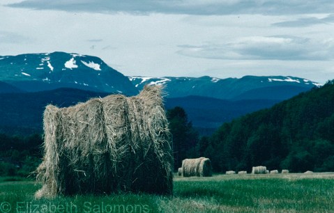
Canada 150: Somewhere Near McBride
Update: My friend tells me this field is along Barrett Station Road near Houston. The mountains are the Telkwa Range. Oops! I was only off by some 500 kilometres.
On the Travel Bucket List of every Canadian should be two trips: (1) a road trip across Canada and (2) the same by train. I’ve almost completed both.
The train trip I’ll save for another post; the road trip was done in several legs, several years apart. (Since Canada is such a vast country, it is my opinion that it is not cheating if you break these trips down into manageable chunks.)
Leg one of my cross-Canada road trip was completed the summer I moved from Vancouver to Toronto. I packed as many of my meager belongings as I could fit into the back of my Honda Civic hatchback, kissed my parents good-bye, got into my car and headed … north.
North? Why not? (What’s a 24-hour detour when you’re about to spend days driving across Canada?)
Yes, I started my trek east by driving north to the Bulkley Valley where some friends of mine were living, and it was only after that visit that I pointed my trusty little car east towards the Rockies.
I took this photo somewhere along the Yellowhead. My foggy memory tells me it was near McBride, but, truthfully, it could have been anywhere between Houston and Jasper. The hay bales are what made me pull over to take a photo.
I love hay bales.
Canada 150: Kamloops Lake
It’s not often that I travel to Alberta by car, but when I do, I am always struck by the diverse landscape of the province where I live. In just one day’s travel, you drive through the flat delta of the Fraser River, head up the narrow gorges of the Fraser Canyon or the steep incline of the Coquihalla Pass (depending on which route you take), then it’s through the grasslands and forests of the Interior before crossing a mountain range or three.
This photo, which I took from the Trans-Canada Highway during the summer of 2009, is of Kamloops Lake. I love the landscape around Kamloops. It’s got mountains, it’s got valleys, it’s got deserts.
And look. It’s got trains, too.

Canada 150: Broken Group Islands
Happy New Year, everyone! I think we’re all glad to see the backside of 2016, but the big question for today is: what will 2017 bring us?
For Canadians, 2017 is going to be one long party. Yup, it’s our sesquicentennial (enriching your word power, I am). All that fancy word means is this: we Canadians are celebrating our nation’s 150th birthday in 2017. Canada 150 is what we are calling this little party.
Canada came into existence, formally, on July 1, 1867, when the British Parliament passed the British North America Act of 1867 (commonly referred to as Confederation). But although our official birthday isn’t until July 1, the party is already well underway. Even Lonely Planet has taken note. It has Canada as the # 1 choice in its list of places to visit in 2017. It’s even posted a free PDF chapter of how to plan your trip. You can download it here.
The Canadian government is encouraging that spirit of travel and adventure by giving anyone and everyone (that’s you, me, and the entire world — everyone is invited!) free admission to any of its Parks Canada locations. Which are quite a few: 47 national parks, 171 national historic sites, and four marine conservation areas. You can order your 2017 Discovery Pass here.
As for my part in celebrating Canada’s sesquicentennial, I’ve decided to take you all on a cross-Canada photographic tour. I’ve been blessed by the opportunity to live in three different provinces of this great nation, and I have travelled from coast to coast to coast through much of the rest of the country. And so, at least once a month throughout 2017 (maybe more often if I get really excited about this), I will post a photo from a different province or territory of Canada.
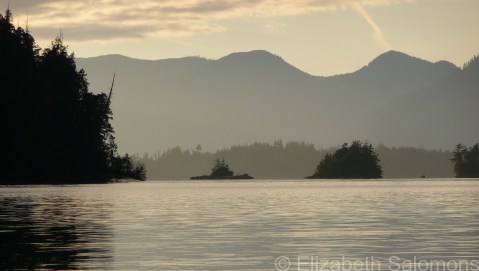
To begin: the Broken Group Islands. Accessible only by boat, these islands are located on the west coast of Vancouver Island in Pacific Rim National Park Reserve. (Your 2017 Discovery Pass will get you there!) I’ve camped and kayaked in the Broken Group Islands twice already and hope to go back many more times as they are, quite simply, one of the most spectacular places I’ve ever been to. Anywhere.
The Broken Group Islands are also the westernmost point of Canada that I’ve been to. I took this photo in August 2008 from the beach on Gibraltar Island where my friends and I were camped.