
Hornby Island
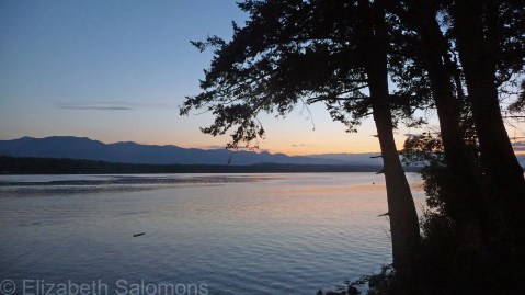
The last island on my tour of BC’s Gulf Islands ― until I have a chance to explore some more, that is ― is Hornby Island.
Hornby is part of a group of islands known as the Northern Gulf Islands (as opposed to the Southern Gulf Islands that Pender, Salt Spring, and Galiano are grouped with). It’s a bit of a hike to get to Hornby from Vancouver: you first take a ferry from Horseshoe Bay to Nanaimo on Vancouver Island, then drive up island for about an hour, hop on another ferry at Bulkley Bay that takes you to Denman Island, drive across Denman, and then, finally, take yet another ferry to get to Hornby. (Denmanites refer to their island as the “bridge” to Hornby because most tourists and campers whiz across it without stopping.)
All told, it’s a good half-day trek. My friends and I went to Hornby on a long weekend, but, even with three days, the trip still felt rushed. If you are coming from Vancouver, I highly recommend going to Hornby only if you have at least four or five days, ideally a week, to make the travel time and ferry expense worth your while.


Hornby Island has a year-round population of 1000 and its size of 30 square kilometres makes it one of the smallest of the Gulf Islands. It’s named after Rear Admiral Phipps Hornby, a Brit, who was the Commander of the Pacific Station in the 1850s. The island’s Mount Geoffrey is named after his son.
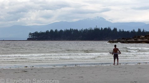
Like the rest of the Gulf Islands, Hornby offers hiking, wine-tasting, and studio tours. It is also popular with cyclists and mountain bikers. The beach at Tribune Bay is beautiful and I added it to my list of favourite beaches as soon as I set eyes on it. I’m looking forward to spending a lot of time on that beach when I return to Hornby Island.
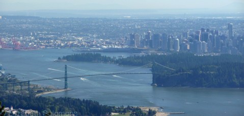
Happy Birthday, Lions Gate Bridge!

The Lions Gate Bridge is having a birthday, and it’s a big one. It was on November 14, 1938 ― 75 years ago today ― that the bridge was first opened to vehicle traffic. The Guinness family (yes, that Guinness family ― the one that brews the beer) wanted a bridge across the First Narrows of Burrard Inlet to provide access to the land on the North Shore they were hoping to develop. (The area was both then and now known as the British Properties.) To help move things along, the Guinness family offered to pay for the bridge to be built, and the City of Vancouver found itself with an offer it could not refuse.

It took 18 months to build the Lions Gate Bridge, its construction came in under budget, and, at the time of its opening, its 1.8 km length made it the longest suspension bridge in the British Empire. It is named after the Lions, the twin mountain peaks on the North Shore that face the city. Two Art Deco–style lions guard the approach to the bridge’s south end.
In 1955, the Guinness family sold the bridge to the province for exactly the same amount that they spent on building it ― a mere $6 million. The Guinness family also paid for the lights that have adorned the bridge’s cables since 1986, as a gift to commemorate Expo 86.

More than 60,000 cars cross the Lions Gate Bridge each day, a number it was never designed to accommodate and which has often led to it being called “Canada’s most scenic traffic jam.” By the 1990s, the bridge was showing its age and serious consideration was given to replacing it. Instead, it was restored and given a seismic retrofit, and its deck was replaced, all at a cost of more than $100 million. All work was done in 12 months between 2000 and 2001 without any disruption of daytime traffic ― no small feat in a city where traffic is easily snarled when any one of its bridges is closed. In 2004, the Lions Gate Bridge was designated a National Historic Site of Canada.
Galiano Island

Next up on my tour of BC’s Gulf Islands is Galiano Island. Galiano is named after the Spanish explorer Dionisio Alcalá Galiano, who sailed and mapped the Gulf and San Juan Islands in 1792. It is a long island (27 km tip to tip) and a narrow one (6 km across at its widest point, but only 1.6 km across at its narrowest). As the most northeastern of the Southern Gulf Islands, it is the island most easily accessed from Vancouver, but it is less developed and has fewer services than the others. That’s due to its rocky geography ― it hasn’t the farming history that the other islands have. In fact, until 20 years ago, the northeastern half of Galiano was a tree farm, which is why most of its 1200 year-round residents live at the south end.
I’ve been to Galiano a handful of times. The campground at Montague Harbour Marine Provincial Park is one of my favourite campgrounds anywhere because of its beautiful white-shell beaches. Kayaks can be rented at Montague Harbour Marina, and there is nothing better than a cold beer on the marina’s waterfront deck after a day of paddling around Galiano’s rocky shores. If you prefer to keep your feet on terra firma, there’s plenty of hiking to be found ― even a mountain (Mount Galiano) to climb ― and plenty more cold beverages available afterwards at the Hummingbird Pub.
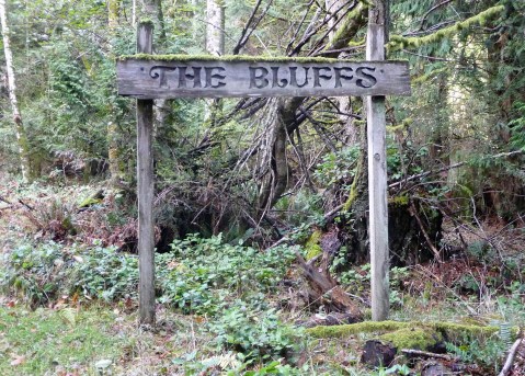
But my favourite Galiano pastime, which I try to do every time I’m on the island (rain or shine) is to hike up to The Bluffs. These cliffs, covered in arbutus and Garry Oak trees, overlook Active Pass, making them a prime venue for ferryspotting. If you have time for only one activity while on Galiano, make it this one. The views are spectacular.

Castel Sant’Angelo

Vancouver Opera has just finished its run of Puccini’s Tosca for which it received rave reviews. I got to see it on opening night and enjoyed it immensely. I’ve been looking forward to hearing this particular opera for many years ― and not only because I have yet to meet a Puccini opera I didn’t love.
No, I’ve been wanting to hear Tosca ever since the friend who introduced me to opera told me how, at the end of the opera, Tosca jumps to her death from the ramparts of Castel Sant’Angelo. Why did this make such an impact on me? Because my friend told me the story of Tosca’s demise when we were standing on the ramparts of Castel Sant’Angelo. (There’s nothing like context to make opera come alive!)
If you’re wondering how high those ramparts might be, here’s a photo of the Tiber that I took when I turned around after taking the above photo.

Another interesting detail about Tosca: Act I is set in the Church of Sant’Andrea della Valle. My friends and I discovered this bit of trivia when we wandered into the church, which just happened to be located on the same street as our Roman hotel. Lesson learned: you never know what awaits you inside a Roman church.
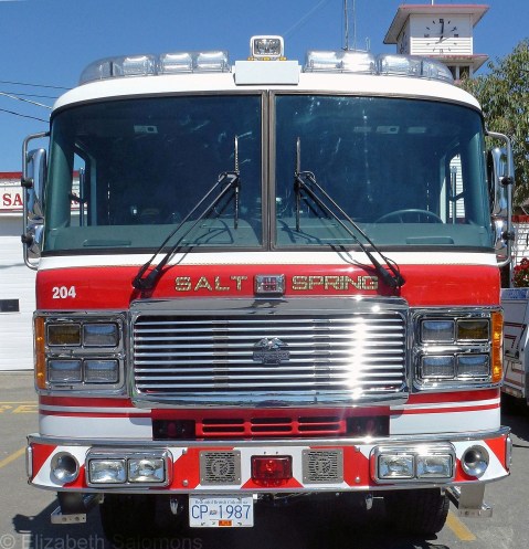
Salt Spring Island
The absolute best way to explore the Gulf Islands is to latch onto a local. I’m fortunate that one of my oldest friends lives on Salt Spring Island, and that I am welcome whenever I need an “island fix.” I call her up, we settle on a weekend, and off I go. Hers is the best B&B I’ve ever stayed at, no contest.
Thanks to my friend’s hospitality, I’ve visited Salt Spring Island in every season and it’s the Gulf Island I know best.
Salt Spring Island is named after the salt springs at its north end. It was long spelled Salt Spring (two words) until 1905, when the Geographic Board of Canada stuck its oar in and decided that it should be Saltspring (one word). Locals are divided on the issue, although the two-word version tends to be preferred. One federal department (Geographical Names Board of Canada ― the committee of Natural Resources Canada responsible for all place names in this country) spells the island’s name as Saltspring, while another federal department (Canada Post ― responsible for … uh … well … we’re not too sure anymore) spells the island’s name as Salt Spring.
Salt Spring? Or is it Saltspring? Yes, it’s spelling inconsistencies like these that drive editors slowly mad.
Salt Spring has some great place names. My friend walks her dog at Duck Creek Park, and we have hiked Channel Ridge. I once made her drive past a house for sale on North End Road simply because I could imagine myself with a mailing address that read “North End Road, Salt Spring Island.” (Seriously, don’t these names sound like they come right out of Anne of Green Gables?)

This view of Vancouver Island is your reward for climbing Channel Ridge.
Located between Galiano Island and Pender Island (to the east) and Vancouver Island (to the south and west), Salt Spring Island is the largest (180 square kilometres) and the most populated (10,500 residents) of the Gulf Islands. It is the only island with its own hospital and it has the Gulf Islands’ only high school. (Students commute from the smaller islands by boat.)
Salt Spring Island has long been known for its eclectic population. It is Coast Salish territory and home to the Tsawout First Nation. The African-Americans came around 1860, looking for a new life free from the racial restrictions of their native California. The first Hawaiians arrived around the same time. They were in BC to work as contract fur traders for the Hudson’s Bay Company and ended up on Salt Spring after their contracts ended. Their descendents still live on the island. The first Japanese settlers arrived in 1890, but only one family (the only one to return after the Japanese-Canadians were interned by the Canadian government in 1942) remains.
The tourists started coming in the 1930s … and they’re still coming. The artists (and more Americans) started coming in the 1960s … and they’re still coming. Salt Spring boasts a large arts community and has been called the best small arts town in Canada and one of the top ten arts communities in North America.
So … what to do when you’re on a Salt Spring Island mini-break?
There’s some terrific hiking on Salt Spring Island.

Hiking in a rainforest in the sunshine is the best. Hiking in a rainforest in the sunshine with a rambunctious Lab leading the way is even better.
There’s also peeking into the windows of old churches and wandering through old cemeteries and taking scenic drives past old farmhouses.


There’s the Salt Spring Island Saturday market. Be careful ― the cash just flies out of your wallet at this place, which I can attest to from personal experience. This outdoor market runs from Easter to the end of October and features 140 vendors, all of whom must “make it, bake it, or grow it” themselves. Many of the island’s artists and artisans sell their wares at this market, as well as the farmers with their fruit and vegetables, eggs and poultry, and lamb. (A dozen different breeds of sheep are raised on the island.) And then there are the bakers, the cheesemakers, and the soapmakers. I am sure there must even be a candlestick-maker.


You can always do a studio tour. Maps for this year-round self-guided, self-drive tour are available on any BC ferry and in various places on the island. Some studios offer tours or a demonstration ― and there’s always plenty of opportunity to sample, look, and buy. (Be sure to stop at the cheesemakers.)
And then there’s wine-tasting at Salt Spring Island’s three wineries. My friend has taken me to two of these, and the only reason we didn’t stop at the third was because we couldn’t find a parking spot ― it was that popular.

Salt Spring’s Mediterranean-like climate is well suited to growing grapes.
My favourite is Garry Oaks Winery. I overdid it though when I bought three bottles of its Pinot Gris, which is not too smart when you are schlepping your way home as a foot passenger on the ferry with your luggage on your back.
At Mistaken Identity Vineyards, we encountered a Tasmanian cheesemaker who wanted to purchase a glass of rosé ― just one ― to enjoy with his picnic lunch. The woman pouring the wine tastings seemed puzzled that he didn’t want an entire bottle, explaining to him that the bottles were screw-top so the wine was safe to take away, but she gladly poured him a glass, and off he went to eat his cheese and sausage and drink his wine at one of their picnic tables.

Garry Oaks Winery is named after the garry oak ― the only oak native to the Pacific Northwest.
It was an idyllic setting for a picnic, to be sure. But the Tasmanian cheesemaker assured the woman behind the counter that he wouldn’t be able to finish off a bottle in the one remaining evening he had left on the island. This declaration prompted a bit of discreet chuckling among my friend, myself, and the woman behind the counter (who recognized my friend as a local, which led to an interesting conversation about how and where they knew each other). All three of us marvelled at a Tasmanian who didn’t think he could finish off a bottle of wine between lunch and breakfast.
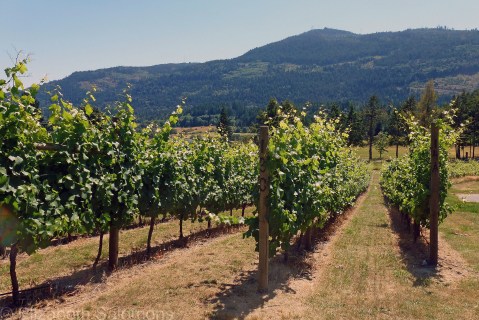
Garry Oak Winery started out as a sheep farm. The conversion from pasture to vineyard was begun in 1999.
If you need a caffeine fix, I recommend Café Talia in Ganges or the Fernwood Cafe located at a beautiful spot overlooking Trincomali Channel. For the best fish and chips on the island, check out the Seaside Restaurant in Vesuvius. Dinner at the Salt Spring Inn is especially fun when your friend knows everyone in the dining room, and if you find yourself waiting for a ferry at Fulford Harbour, stop in for some sustenance at the Tree House Cafe Rock Salt Restaurant and Café.
As for where to stay, accommodation ranges from pitching your tent at Ruckle Provincial Park‘s waterfront campground, renting a self-catering cottage by the week, enjoying the hospitality at a B&B, or pampering yourself at the Salt Spring Spa Resort. But I’m keeping the name and location of my favourite B&B (my friend’s home) a secret.
Because I don’t want to lose my guaranteed reservation status.
Pender Island
The other week, while discussing our mutual plans for the upcoming long weekend, I learned that one of my co-workers has a place on Pender Island.
In Western Canada, weekend places are most often called “cabins.” I point this out because for a while I lived in Ontario, where weekend places are always referred to as “cottages.” People in Toronto talk about their “cottage weekends” and there is a mass exodus from the city every Friday afternoon between the May Long Weekend and Labour Day. (You haven’t experienced traffic if you haven’t driven Highway 11 on a summer weekend.)
Cabin, cottage, tomato, tomahto …You’re probably wondering why I’m going on about this.
It’s because when I hear the word “cottage,” I have in mind a small dwelling right out of the English Cotswolds, complete with thatched roof. But when I hear the word “cabin,” I always picture the log cabin Laura Ingalls Wilder described in Little House in the Big Woods. I used to entertain myself in school by sketching log cabins, complete with smoking chimney made out of stone, in the margins of my notebooks. I dreamed of one day living in such a cabin.
Imagine my surprise when I visited Pender Island a couple of summers ago, and came across my dream cabin. I had no idea it existed outside of my head. But ― there it was. I had already fallen in love with Pender Island on this visit (my first); coming across the cabin only cinched the love I was feeling.
OK, so it’s not exactly a log cabin, but it sure is my idea of pastoral perfection.
Pender Island is one of BC’s Southern Gulf Islands and is sandwiched between Saturna to the east, Mayne to the north, and Salt Spring to the west. Even though they lie within spitting distance of each other, each island has its own unique character, which is why a couple of my friends and I are weekending our way through the Gulf Islands. We try to explore a different island every summer.

Pender Canal
Pender Island is actually two islands: in 1902, a canal was dredged through the isthmus between North and South Pender Islands. The islands were later reunited with a single-lane wooden bridge.

This bridge has connected North and South Pender Islands since 1955.
The island is named after Daniel Pender, a British Royal Navy captain who surveyed the coastal areas of British Columbia between 1857 and 1870.
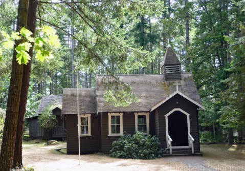
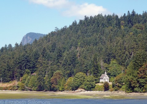
A little brown church (Church of the Good Shepherd) on South Pender Island
Pender Island is about 35 square kilometres in size and has a year-round population of 2500, most of whom live on North Pender Island. That population triples in the summer; I hope to be joining the throng of visitors again soon.

Gowlland Point
Through My Lens: Foggy Vancouver
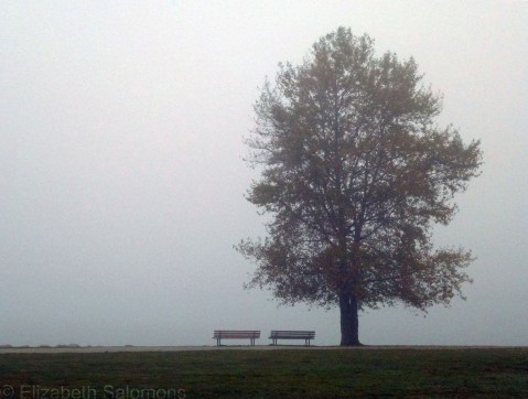
Vancouver has been awash in a pea-soup thick fog the past few days. It’s supposed to lift tomorrow. Apparently the sun is out there somewhere.
Here is a photo I took this afternoon at Vanier Park.
Happy Thanksgiving!
I missed Thanksgiving the year I backpacked around Europe with my girlfriend. We joked about what we thought was our Thanksgiving dinner (bratwurst and sauerkraut in the Munich train station) on the day we thought was Thanksgiving, but we later found out we had the wrong day. I think we even had the wrong week. That’s what happens when you hop on and off trains and check in and out of hostels on a daily basis: the days become a blur.
I remember telling the story of our missed Thanksgiving to two Nebraskan sisters we had met on a train. They looked at me, puzzled. “You can’t have Thanksgiving,” they said in unison. “You didn’t have pilgrims!”
Uh, yeah. Right.
It never made sense to me why turkey had to be eaten with cranberries until my first trip to Massachusetts. There, while camping on Cape Cod, I found wild cranberries growing every which way I turned. And Cape Cod, of course, is just around the corner from Plymouth, where the aforementioned all-important pilgrims first landed on America soil.
“Aha!” I said to myself. “It’s all those pilgrims’ fault that we are stuck eating cranberries every holiday dinner.”
Cranberries grow in British Columbia, too. In fact, this province produces 12 percent of North America’s cranberry supply.
I will have Thanksgiving dinner tonight with my family. There will be cranberries. And pumpkin. But no turkey.
And no, Canada didn’t have pilgrims. We are thankful, none-the-less.
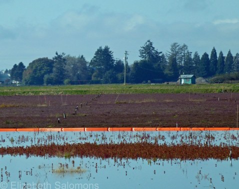
Cranberry Bog, Richmond, BC
Happy Birthday, Stanley Park!
Stanley Park turns 125 today. The city threw a big party in the park last August to celebrate the occasion, but its actual birthday is today, as it was on September 27, 1888, that the park was first officially opened to the public.
At 1000 acres, Stanley Park is the largest of Vancouver’s parks, and also its most popular. It contains an estimated 500,000 fir, hemlock, and cedar trees, and has three beaches, a lake, a lagoon, an 8.8-km seawall, and many more kilometres of walking trails that meander through its interior.
It’s named after Lord Stanley of Preston, Governor General of Canada from 1888 to 1893.
University of British Columbia
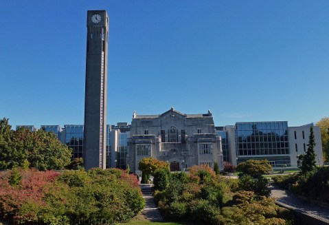
The last school I want to show you on my tour of schools I’ve photographed is the University of British Columbia. Like Simon Fraser University, UBC is situated a ways away from the hustle and bustle of the city centre ― its main campus is located at the western tip of Point Grey, a peninsula to the west of Vancouver’s toniest neighbourhoods.
UBC is a hodge-podge of architectural styles. For one, it’s got your neo-Gothic. This is the Chemistry Building, one of the first three buildings constructed on the Point Grey campus. That was back in 1925.

For another, it’s got your Brutalism. The Buchanan Tower was built in 1972.

And it’s got your postmodernism. This is the Koerner Library, which was designed by Arthur Erickson and completed in 1997.

UBC is fond of combining architectural styles when it builds additions to existing buildings. The Main Library, another of the three buildings constructed in 1925, morphed into the Irving K. Barber Learning Centre in 2008. The neo-Gothic centre is the original building, now surrounded by a postmodern glass structure.
Here’s a look at it from another angle.

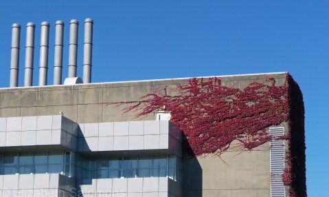
Four wings were added to the Chemistry Building between 1959 and 1989. This is a corner of one of those wings, built in the Brutalist style.
And this postmodern structure is an addition to the Henry Angus Building, which houses the Sauder School of Business. The addition, which opened in 2012, is wrapped around the original building, which was built in 1965 and expanded in 1976.

With 50,000 students, UBC is Canada’s fourth largest university and the largest in Western Canada. These days, the Point Grey campus is one massive construction site. In the past year, work was completed on a new trolley bus loop, upgrades to primary pedestrian corridors (which for some reason I have yet to figure out are called “malls” here), and a new fountain in Martha Piper Plaza. Building construction currently underway includes a new Student Union Building, the new Centre for Brain Health at UBC Hospital, and expansion of the UBC Bookstore. A new building that will house the Faculty of Education is scheduled to break ground this winter.
UBC’s Class of 2016 fittingly calls itself the Class of Construction.
