
Canada 150: Tr’ochëk

Here is one last photo from North of 60. This is fireweed, the official flower of Yukon. It takes its name from the fact that it is one of the first plants to grow after a forest fire.
I took this photo at Tr’ochëk, a former settlement of the Tr’ondëk Hwëch’in First Nation. It’s also known as Moosehide. Located about 5 km down the Yukon River from Dawson City, the settlement was abandoned in the 1960s after its only school was closed. Today, it is an important gathering place and a seasonal fishing camp for the Tr’ondëk Hwëch’in First Nation.
Canada 150: Inuvik
Our road trip up the Dempster led us, eventually, to Inuvik. Located 200 km north of the Arctic Circle, Inuvik was built in the 1950s in its present location in the Mackenzie River delta to function as the region’s administrative centre.
Inuvik is the northernmost point of Canada that I’ve ever been to. Until this year, it was also the northernmost point in Canada that you could drive to in the summer. In the winter, the Dempster Highway continues north to Tuktoyaktuk for another 194 km along an ice road formed on the channels of the Mackenzie River delta and the Arctic Ocean. This ice road was only open during the winters, but is being replaced by a new all-season road scheduled to be finished by the end of next summer.
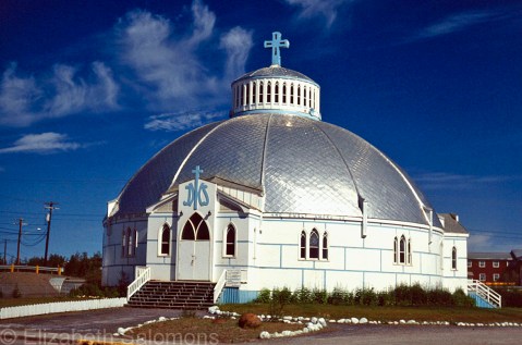
Our Lady of Victory Parish, or the Igloo Church as it is often called, is the community’s Catholic church. It was designed by Brother Maurice Larocque, a missionary from Quebec who spent his entire ministry working in the North. Before he became a priest, he was a carpenter, and he used his skills to design a church that reflected the people who would worship in it. The church was built in the shape of an igloo to be able to deal with the shifting permafrost it stands on.
The Igloo Church is the most photographed building in Inuvik. Naturally, I had to take a photo, too.
Through My Lens: Fountains Abbey Nave
Without the lay brothers who built the abbey and did all the daily chores necessary to keep body and soul together, Fountains Abbey would never have become as wealthy as it did. At the time of Dissolution, the abbey’s land holdings had increased to 500 acres, making it one of the richest religious houses in England.
Which also made Fountains Abbey awfully attractive to Henry VIII, who used the proceeds from dismantling England’s abbeys to fund his military campaigns. (More on that next week.)
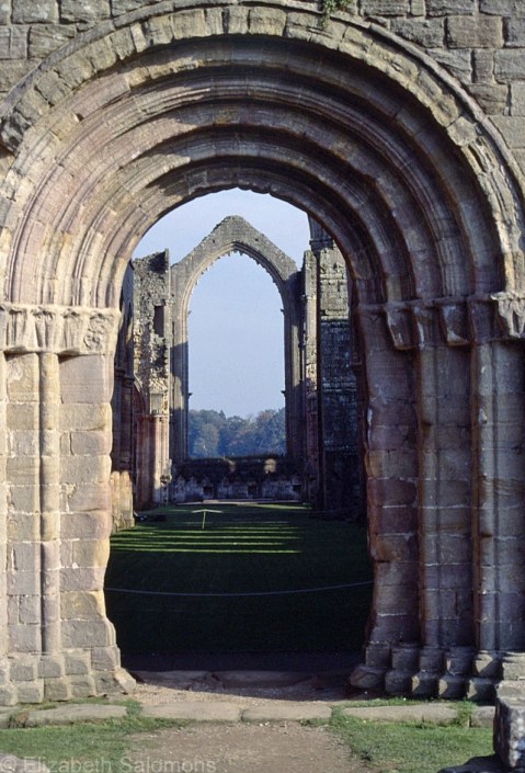
For today, the Fourth Sunday of Lent, I’m posting a photo of the nave of Fountains Abbey. Imagine, if you will, that the roof is still in place and the monks are singing and chanting as they process down this nave towards the Great East Window.
Canada 150: Tsiigehtchic

This photo is of Tsiigehtchic, which is where the Mackenzie River meets the Arctic Red River, and where the Dempster Highway crosses the Mackenzie River. Vehicles cross by ferry in the summer. In the winter, there is an ice crossing.
Tsiigehtchic is the Gwich’in word for “mouth of the iron river.” Iron river (Tsiigehnjik) is their name for the Arctic Red River.
Nagwichoonjik, or “river flowing through a big country,” is what the Gwich’in call the Mackenzie River. The Dene call it Deh Cho, which means “big river.” And its Inuvialuktun name is Kuukpak, which means “great river.”
In case there is any doubt, the Mackenzie is a big river. At 4241 km long, it’s the largest and longest river in Canada, and the second largest and longest in North America. (Only the Mississippi is longer.) The Mackenzie River’s watershed covers one-fifth of Canada’s land mass.
The river got its English name from Alexander Mackenzie, who followed its length to the Arctic Ocean in 1789. He hoped the river would empty into the Pacific Ocean. When he realized it did not, he is said to have named it Disappointment River.
That’s an awful lot of names for one river. Whatever you call it, it’s worth crossing.
Through My Lens: Fountains Abbey Cellarium

For the Third Sunday of Lent, I’m posting a photo of the cellarium at Fountains Abbey. Cellarium is a fancy monasterial word for “storeroom,” and this one was located beneath the dormitory where the lay brothers slept. It was used mainly to store food.
Fountains Abbey had two orders of monks: choir brothers and lay brothers. The choir brothers did all the praying and singing, while the lay brothers did all the manual labour required to run the abbey, including stonework and metalwork, tanning hides and making shoes, brewing and baking, and herding sheep.
Through My Lens: Fountains Abbey Great East Window
Fountains Abbey was founded by 13 rebel Benedictine monks from St. Mary’s Abbey in York. They were sent packing because they wanted to live by a stricter rule than the Rule of St. Benedict that the monks in York followed.
The rebel monks were given 70 acres of land in a valley near Ripon in North Yorkshire. They decided to establish a Cistercian order, which is a French monastic order. Cistercian monks supported themselves by farming. The land near Ripon had everything the rebel monks needed: a valley setting to shelter them from the North Yorkshire weather, stone and timber for building, and plenty of water. The name of the abbey, St. Mary of Fountains, is thought to have originated from some nearby springs.
Not long after founding their abbey, the monks built a church out of stone. The Great East Window above the Chapel of Nine Altars behind the High Altar is featured in this photo, which I am posting for the Second Sunday of Lent.

Through My Lens: Fountains Abbey and the River Skell
For this year’s Lenten series, I’m going to follow up on last year’s series of photos of Mission Abbey with photos of another abbey. This time, though, we are once again back on the other side of the pond.
This year’s abbey is Fountains Abbey in North Yorkshire, England. It was founded in 1132 and operated as a religious house until 1539 when it was surrendered to the Crown during the Dissolution of the Monasteries under Henry VIII.
For the First Sunday of Lent, here is the view of Fountains Abbey when walking towards it from the west. All that is visible of the abbey is the church tower, which is reflected in the River Skell.

Anna’s Hummingbird
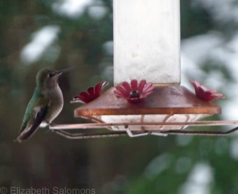
I took this photo of an Anna’s Hummingbird a few weeks ago during our last snowstorm. I was housebound during that storm because I was hanging out in Solo. If you look closely, you can see that the water in the feeder is almost frozen solid. I’m sure that hummingbird was as confused as I was by the cold weather.
Why am I posting this photo today? Because this morning I spent nearly an hour watching big fat snowflakes fall from the sky.
C’mon. It’s almost March. More snow??
Vancouver has had twice as much snow this winter as Edmonton where it’s winter seven months of the year. (I can say that because I grew up in Edmonton. I know winter. Er … I used to know winter.)
Anna’s Hummingbirds do not migrate south from Vancouver for the winter, thanks to the proliferation of backyard feeders like this one. I still can’t get my head around the fact that hummingbirds are here year-round.
I just hope all that hovering they do kept those tiny birds warm this winter.
Canada 150: Dempster Highway

If you’ve already driven some 2500 kilometres to get from Edmonton to Dawson City, what’s another 800 klicks to go to Inuvik for lunch?
That’s what we thought.
The above photo is of the Dempster Highway, the only road from Dawson to Inuvik. It’s also the only all-weather road in Canada to cross the Arctic Circle. Because of the permafrost, it is surfaced with gravel. When we returned to Dawson City, we were surprised to learn it was rare not to pop a tire or two driving the Dempster Highway to Inuvik and back.
I guess we got lucky.
There’s one place to stop for service along the Dempster Highway and that’s at Eagle Plains, which is the halfway point between Dawson and Inuvik. We filled up with gas there, but camped overnight closer to Inuvik simply by pitching our tents on the shoulder of the highway.
It wasn’t like there was much traffic to keep us awake.
Canada 150: Dawson City
On leg three of my cross-Canada road trip, I drove from Edmonton to Dawson City with a friend. And it was on this trip that I learned a valuable lesson about travelling that has stuck with me ever since.
Always (always, always!!) do your research before you leave home.
My friend and I, both living in Toronto at the time, decided to drive to Dawson City from Edmonton instead of Whitehorse because we both had people we wanted to visit in Edmonton. We flew separately, a few days apart, and I booked us a rental car at the Edmonton International Airport where I would meet her.
I still remember the exact moment the sinking feeling formed in the pit of my stomach. Spread out on the floor of my brother’s living room was a road map that I had been using to calculate how long it would take us to drive to Dawson City. (This was back in the olden days, folks, long before Google Maps.) I started at it in disbelief. Turns out that, even after flying across four provinces, my friend and I were only halfway to the Yukon from Toronto. We had a 36-hour drive ahead of us.
Oops.
But you know what? It was a stunning road trip. We spent our first night with an aunt of mine who lived on a farm in northern Alberta, stopped for a minute the next day in Dawson Creek, BC, to take our obligatory photos at Mile 0 of the Alaska Highway, and camped that night near the BC–Yukon border where we soaked our weary bodies in Canada’s second-largest hot springs at Liard River.
On our third day, we pushed on until we finally arrived at Dawson City around 1 a.m. My sister, who was working in Dawson for the summer, was up and waiting for us.
I was running on adrenalin by that point and nowhere near ready for bed, so my sister took me to the top of Midnight Dome for my first view of the town. It was early July and at that hour it was dusky, but light enough to understand why they call it Land of the Midnight Sun. I took this photo of the view of Dawson City and the Yukon River from Midnight Dome the next day.
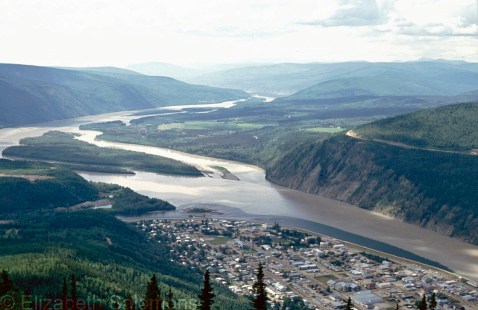
Dawson City was the epicentre of the Klondike Gold Rush. After gold was discovered in 1896, an estimated 100,000 people poured into the area, hoping to make their fortune. Almost overnight, Dawson became the largest city west of Winnipeg and north of Seattle.
It was over as quickly as it started. The miners moved on to Alaska after gold was discovered there in 1899. Gold mining still goes on in Dawson today, but most of the town’s economy is based on tourism, which celebrates its Klondike past.
The Klondike Gold Rush transformed all of Western Canada, however. The population of Vancouver doubled and Edmonton’s tripled in those few short years as both cities served as gateways to the Klondike.
Just as Edmonton did for my friend and I.


