
Through My Lens: Celebration of Light
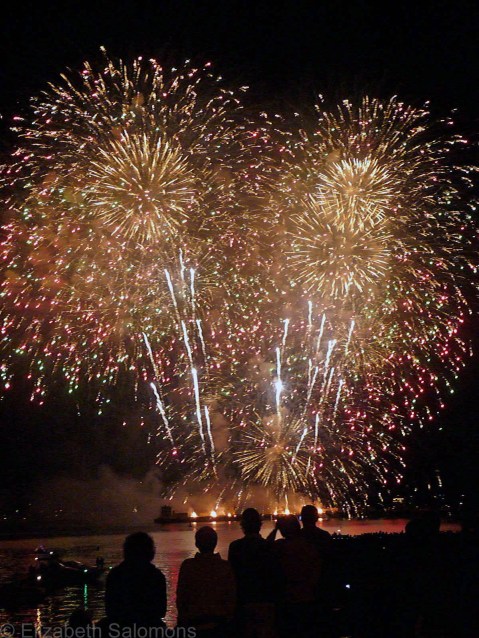
For three nights every summer, three different countries compete in Vancouver’s annual fireworks competition, known as the Celebration of Light. More than half a million people from the ’burbs descend upon my neighbourhood to watch some pretty impressive pyrotechnic displays set off from a barge moored in English Bay. This year will be the 27th consecutive competition. It’s the longest running offshore fireworks competition in the world and, I am told, BC’s largest event.
Which is obvious once you’ve tried to make your way through those crowds.
I used to overlook English Bay from a ninth floor apartment and I could watch from my balcony. Now, I walk down to the beach a few minutes before they’re scheduled to start and I always have a great view.
It’s one of the perks of living in the West End.
Through My Lens: Pool With a View

One activity that is definitely possible here only in the summer is swimming in one of Vancouver’s five outdoor pools. This being Canada, the pools are only open between May and September. Two of them front English Bay, so they qualify as “oceanfront pools.” (The mountain views are a bonus.)
By no means is Vancouver a tropical destination, but for a couple months every year we put on a pretty good pretense.
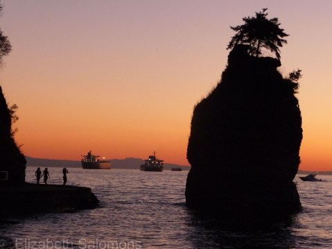
Through My Lens: Siwash Rock at Dusk
After a miserable fall, a weird and wacky winter, and a cold, wet spring, we are finally experiencing some summer weather. And you know what? It’s absolutely spectacular.
Vancouver is at its best in the summer. Because of that, and because summer is usually the busiest time in my line of business, I rarely do my travelling in July and August.
This year is going to be an exception, however, as I’m gearing up to spend the summer in Europe. I’m incredibly excited about the opportunity that has come my way. But I am also feeling just a little bit wistful about all the fun I am going to miss right here at home.
And so, for the next few posts, I’m going to show you what is so spectacular about Vancouver in the summer.
For my first photo, I give you Siwash Rock at dusk. Dusk in Vancouver in the summer is late — I took this photo in early August just after 9 p.m. — and that means there is no excuse for not going for a long walk after work.
Walking the Stanley Park seawall is probably one of the city’s most popular activities for locals and tourists alike. And although we locals do it year round, it is so much more pleasant on a summer evening.
Canada 150: Neepawa
While I was on leg one of my cross-Canada road trip, I made a small detour to Neepawa, Manitoba. It wasn’t a long detour — certainly not as long as my first detour to the Bulkley Valley. But seeing as Neepawa is not on the Trans-Canada Highway, it was, technically, out of the way.
I remember it being a spur-of-the-moment decision. While studying the road map, I turned to my sister (who had by this time joined me on my cross-Canada road trip) and I said, “Hey, let’s stop in Neepawa!”
Why Neepawa?
Neepawa is the birthplace of Margaret Laurence, the much-lauded Canadian author. Back in the day, her novel The Stone Angel was required reading in most Canadian high school English classes. That novel put the fictional town of Manawaka on the literary map of Canada. And Manawaka was inspired by the town of Neepawa.
Our quick stop in Neepawa proved to be one of the highlights of that road trip. We didn’t know this until we got there, but the small town is an oasis in the middle of the Canadian prairie, filled with big, old leafy trees and big, old lovely houses. One of those houses, the one in which Margaret Laurence grew up, is now a small museum, which we made a point of visiting.
We also made our way to the cemetery where Laurence is buried and where the original stone angel stands. The statue is part of the headstone for John Andrew Davidson, a Manitoba politician who died in 1903. It has no wings, but apparently it was called an angel by the residents of Neepawa long before Margaret Laurence wrote her novel.
And here she is.

Canada 150: Shackleton
It turns out I have almost no photos of Saskatchewan. Apparently it is a place I only drive through or fly over.
To the best of my memory, the only night I spent in Saskatchewan was the time when the car in which I was a passenger hit a deer. The car was a mess, the deer even more so. Do you know how dark it gets in the middle of the prairie? We could not see our hands in front of our faces. Eventually my parents and my sister and I were rescued by an RCMP officer who dropped us off at some motel in Estevan.
However, it also turns out that the province where I have spent so little time actually played a huge role in my family’s history. My grandparents — two people I never got the chance to meet — immigrated to Saskatchewan. They left the Netherlands by boat intending to go to Alberta, but changed their minds somewhere in the middle of the Atlantic Ocean and decided to head to Saskatchewan instead.
This was in 1928.
For those readers who don’t know much Canadian history, let’s just say the 1930s were not kind to prairie farmers. Twelve years and six children later, my grandparents abandoned the farm to the bank and made a beeline for Alberta, their original destination, where potatoes became the crop that finally turned their fortunes around.
Many decades later, I asked my dad to show me the farm where he was born and the nearby village of Shackleton. It wasn’t more than a few hours’ drive from Lethbridge, where he was then living.
I expected to learn something about my family’s history during our little road trip, but when I saw the almost-deserted village that is Shackleton today, I was surprised at my reaction. It was visceral and all I could think was: How on earth did my grandmother have the strength to not get right back on the train and insist that she and her new husband return to Holland?
The farmer who owned the land my dad’s family had farmed remembered my dad and gave us free rein to wander around. Dad had me take a photo of him standing in the middle of the vegetable garden where he estimated the house he had been born in once stood.
The house was long gone as well as all of the other buildings dating back to the 1930s — except for this shed. Dad says his father used it to store his McCormick Deering steel-wheeled tractor.

One last thought: Apart from my reaction while looking over the village of Shackleton, what struck me most about our visit was a low dike-like mound that separated the fields from the house and other farm buildings. When I asked Dad what it was for, he told me it had been formed by the dust storms. The dirt blew in across the fields, but was stopped from reaching the buildings by a row of shrubs. With each successive dust storm, the mound grew taller. Eventually, when the dust storms finally stopped, grass began to grow on top of it.
And there we were, some 70 years later, standing on land that still showed the scars of the great dust storms of the 1930s.
If that’s not one of the most powerful history lessons I’ve ever had, I don’t know what is.
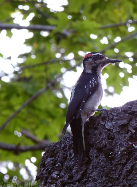
Hairy Woodpecker
I was on Salt Spring Island again this past weekend, and I met a new friend.
This is a Hairy Woodpecker. He’s not that big, but he sure makes a lot of noise for his size. He was busy making himself heard on the wildlife tree in my friend’s front yard, so I walked over to introduce myself.
And to take this photo.
Through My Lens: Steveston Boats

Steveston is a fishing village at the mouth of the South Arm of the Fraser River. It’s been there awhile, since the 1880s, and has a history that is equally fascinating and tragic. Nowadays, it’s the largest commercial fishing harbour in Canada.
Here’s a photo I took last night.
River Otter
In my last post, I mentioned that one of Lost Lagoon’s four remaining Mute Swans had been killed by a river otter. These furry fellows can be found in Lost Lagoon, but also like to hang out wherever there’s fish. Sometimes, that brings them to the beach in English Bay
Which is where I took this photo.
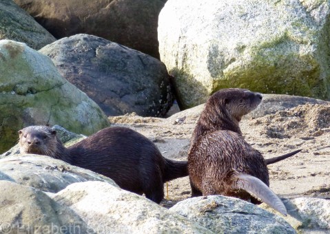
River otters are not the same as sea otters, so don’t be confused by the fact that they can be found near the ocean. They go wherever the fish are, so if that means they hang out on the beach, so be it.
Sea otters, I’ve been told, are not found in the Salish Sea. They live on the west coast of Vancouver Island or along BC’s northern coast. One clue, apparently, to tell the two types of otters apart: river otters almost never swim on their backs, while sea otters often do.
Mute Swan
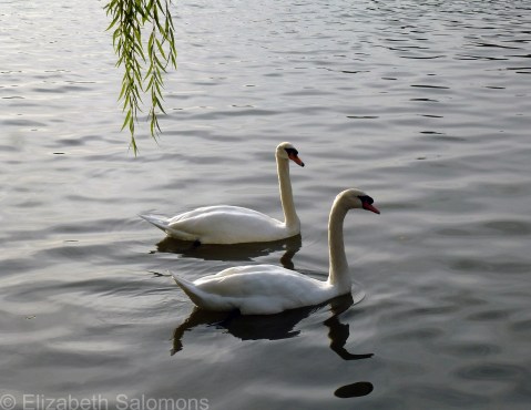
Indulge me, if you will, as I post yet another set of bird photos. This is the Mute Swan, which, until last August, was a common sight at Stanley Park’s Lost Lagoon.
The reason Lost Lagoon no longer has any resident swans is that the last three swans were officially retired and now live at an animal sanctuary somewhere in the Fraser Valley. The move came after a fourth swan was killed by river otters. The swans are geriatric, and it was decided they should live out their remaining years without the threat of predators.

The Mute Swan is not native to North American, but you see them everywhere on this continent, mainly in city parks. Back in the 1960s, there were at least 70 of them living at Lost Lagoon. These days, however, the caretakers at Stanley Park are keen to ensure that native species thrive over invasive species. (I could tell you about the blackberries, but that’s a whole other post.)
Don’t worry, though. This isn’t the last you’ll see of swans in Stanley Park. Because the park is on the Pacific Flyway, you have a good chance of seeing either the Trumpeter Swan or the Tundra Swan as they pass through when they migrate — and they are far more likely to stop in if there are no more of the territorial Mute Swans.
But, invasive species or not, aren’t they magnificent creatures?
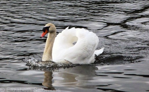
One last note: The Mute Swan is the national bird of Denmark. Does that surprise you? It sure did me. I would have guessed England, but apparently that country is still trying in the process of choosing a national bird. As is Canada.
Northern Flicker
Today is the first day of Vancouver Bird Week and to make it a little more interesting, the city is taking a vote on which of four birds should be Vancouver’s Official Bird.
Vancouver has had a City Bird for three years now. The Northwestern Crow was selected in 2014. In 2015, the honour went to the Black-capped Chickadee and in 2016 to the Peregrine Falcon. But this year is different: the honour of City Bird will become permanent.
Oh, the pressure!
None of the previous City Birds are considered eligible. Bummer, as my favourite Vancouver bird is the Black-capped Chickadee. Also not eligible are any birds that are a city, provincial/state, or national bird elsewhere. (That kinda narrows it down. Another choice of mine would have been the Bald Eagle, of which Vancouver has plenty.) Two final stipulations are that the potential City Bird cannot be viewed negatively by any cultural groups (?), and cannot be commonly found outside of the Pacific Northwest. Vancouver’s City Bird has to be uniquely West Coast.
So, which birds made the Final Four??
Those would be the Spotted Towhee (photo here), Anna’s Hummingbird (photo here), the Varied Thrush (sadly, no photo), and the Northern Flicker (below).
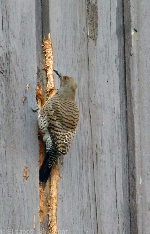
Which one did I vote for?
Now that would be telling.
But may the Best Bird win.
