
Through My Lens: Freezing Fog
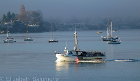
The meteorologists call it freezing fog.
I call it get outside and take some photos.
Dishing: Ask for Luigi

Here’s what happens when you visit a review-worthy restaurant shortly before leaving on your summer holidays: the blog post you wrote sits in your draft folder for months and months until you completely forget about it. We ate at Ask for Luigi on a beautifully hot summer evening last August. Here is what I wrote the next morning.
Note to the host of Ask for Luigi: ignoring the woman for the guy she’s with is not smart in the current century, especially when the gentleman in question is crouched down and clearly pre-occupied with his phone.
That ten-second encounter almost put me off, but I set my ego aside and told the host my name and the number in my party. Ask for Luigi takes walk-in guests only, but anyone not accommodated in the first seating ― we managed to snag the last table ― is texted when their table is ready.
Voted one of Vancouver’s best new restaurants when chef and co-owner J.C. Poirier opened in late 2013, Ask for Luigi is one of the bright spots in Vancouver’s transforming Railtown. Once we were seated, the service was beyond attentive ― our table was wiped down after each course and the reflexes of our server were quicker than all three of us combined when yours truly clumsily knocked over her Spritz ― the Venetian-style aperitivo made with Aperol, Prosecco, and soda water that is the only option for a before-dinner drink.
 The antipasti orders came almost too quickly ― with only 36 seats the emphasis seemed to be on turn-over ― but nothing was going to make us wolf down these delectable platters of perfection. We savoured every bite of anchovy-infused octopus carpaccio, sliced paper thin and liberally sprinkled with baby basil. Luigi’s famous golf ball–sized meatballs were dense and chewy. Smothered with a rich, smooth, crimson tomato sauce and accompanied by toasted
  Tuscan-style bread, they were marred only by the crunch of eggshell in my first bite. Geometrically correct cubes of crispy pork ciccioli, moist and wet on the inside, crunchy on the outside, were served with canary-yellow saffron aioli and deep-fried shishito peppers — a sweet green pepper about the size of my little finger. About one in ten shishito peppers are spicy — my sister was the lucky one in our group.

On to the next course. Tagliatelle with rabbit and olives was flawless, the olive taste subtle but present, and the shredded rabbit liberally coated with a creamy sauce. The rye penne, on the other hand, was overcooked, although not the creamy egg yolk placed on top, nor the gently sautéed broccolini and perfectly crisped guanciale. The pasta special ― conchiglie with garlic sausage, pale kernels of organic corn, and black summer truffle ― was the surprise of the night with its spicy kick and sweet taste of summer. All pasta is made fresh daily and served family style. (Gluten-free options are available.)

Two courses would be enough to fill any sane person, but we soldiered on. The vanilla-bean panna cotta was particularly creamy and made complete by almond biscotti and delicately stewed prunes. Chocolate budino ― a flourless cake with 70 percent chocolate ― was as intense as you would expect a flourless cake with that much chocolate to be. A mini loaf of warm olive oil cake, topped with a quenelle of rich ricotta cheese, was nestled on a bed of glazed orange slices.

The rustic décor was pleasing ― the desserts were served on mismatched china and the wine in small juice-sized glasses ― but pity the poor sods stuck in the back corner, too far from the wide-open windows or floor fans to get any respite from the August heat. Extra entertainment (in addition to yours truly spilling her drink at the start of the meal) was provided when my dining companions recognized a well-known actress sitting behind my right shoulder ― although, she wasn’t so famous that they were sure of her name. Each then whipped out their respective smart phones to check if they were right, while I remained focus on photographing our food.
We’ll go back to Ask for Luigi, but I’m thinking only if we can squeeze into the first seating again; I’m not convinced it would be worth an hour or more wait.
Note: The benefit of waiting three months to post a review is that I can change my assessment: I have decided I do want to go back to Ask for Luigi, regardless of the wait time, as long as I am with people whose company I enjoy. (Which is usually what happens when I eat out, so I should be all right.)
Through My Lens: English Bay

Of course, I don’t need to take a ferry ride to find an awesome view.
This photo was taken from the Stanley Park seawall a couple of Sundays ago. The wind (and the surf) was up, so I had a bracing walk.
My favourite kind of seawall walk.
Through My Lens: Sansum Narrows
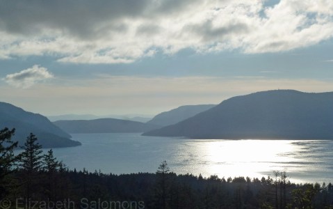
Naturally, a mini-break on Salt Spring Island means photos were taken.
This view from Salt Spring’s Channel Ridge is of Sansum Narrows. The land mass to the far left is still part of Salt Spring Island, but straight ahead and to the right are Vancouver Island.
City of Light
My sister and I, along with one of my closest friends, were wandering the streets of Paris, admiring the lights of the season in the City of Light. It was magical. It was Christmas Eve, 2010.
We made our way to Notre-Dame Cathedral. The streets radiating away from the square in front of the cathedral were filled with French police officers sitting in well-lit white police vans, each one eating a rather fine-looking dinner from a take-out container. We approached the cathedral. A pair of cops eyed us carefully as we walked between them to enter the church.
It was unnerving, to say the least. The scene was repeated on New Year’s Eve when my friend and I crossed the Seine in front of the Eiffel Tower. We stopped to take photos of the tower, then I began taking photos of the police officers once again eating fancy dinners in white police vans parked along the bridge. I hadn’t taken more than one or two shots when the driver’s door of the van I was photographing opened. The officer got out and began to walk towards me, and I quickly tucked my camera into my pocket and turned away. Message delivered, the cop returned to the warmth of his van and his waiting dinner. My heart was pounding.
On Christmas Eve, after we exited Notre-Dame Cathedral, my friend marched up to one of the police officers standing nearby. These were big guys. They had big guns ― bigger than any I had ever seen up close. I had no idea what she was planning to do. But as soon as my friend asked (in French) for directions to the nearest Métro entrance, the cops smiled and laughed and showed us their friendly side. It was a welcome relief from the gravity of their security duties.
“I was beginning to feel so uptight,” my friend told me later. “I had to put a voice to the men with the guns.”
As it turned out, the officers sent us around in circles ― to be honest, I think they were less familiar with Paris than we were because they pointed us in the exact opposite direction that we needed to go ― but eventually we found the Métro and made our way home.
This was five years ago. It seemed to us like your usual Christmas Eve, but we were intimidated by the heavy police presence. Thinking about it later, I surmised that the high-level security must be routine near Parisian monuments on nights that attract large crowds. But because it was unlike anything I’d seen in my own country, the sense of intimidation I was experiencing made me feel like a naive Canadian who knew nothing of the real world.
If my heart was pounding then, what would it be doing now, in Paris’s current state of emergency?
Ten months ago, I wrote about how I was at a loss for words to express what I was feeling about horrific events in Paris. This week, once again, I am feeling just as lost. I contacted my Parisian friend who lives here in Vancouver, anxious about what he would tell me because I knew he, being of the same age and social stratum as most of the victims, would know someone affected by the attacks.
I was right. He did. Although all of his friends and family are safe, one of his friends lost someone at the Bataclan. What is that ― three degrees of separation? It feels closer.
The arrondissement that was attacked last Friday night is not one where tourists typically hang out ― it is where young Parisians of all backgrounds live and work and play. It was a neighbourhood not unlike the one where I spent three months ― what Parisians refer to as bobo (short for bourgeois–bohemian) ― and not unlike my own neighbourhood here in Vancouver. All weekend I wondered how I might have reacted had attacks of this nature occurred while I was living in Paris, while my friend and I enjoyed our glass of wine in a café in my arrondissement.
And, as I wondered, I thought again of how inadequate words can be at a time like this. This time, however, as soon as I heard about the attacks in Paris, I thought immediately of a photo I had taken that holiday season almost five years ago.
It was the one I took just before the French police officer frightened me into putting away my camera.

If you take anything away from the words I’ve written here, it’s this: Paris is, and always will be, my city of light.
And only light can overcome darkness.
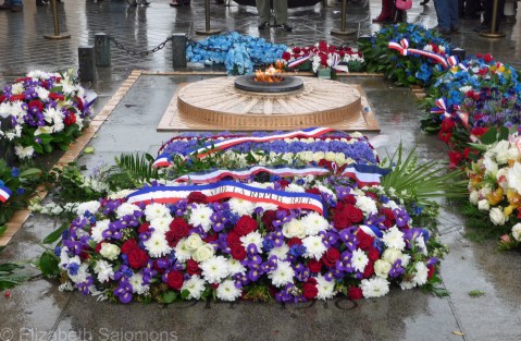
Armistice Day
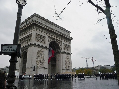
With a bit of a shock, I realized this morning that exactly five years ago today I stood shivering for several hours in the cold and rain across from the Arc de Triomphe in Paris. Just as it is in most provinces of Canada, including my own, November 11 is a public holiday in France. The French refer to it as Armistice Day, in recognition of the end of World War I, whereas in Canada we call it Remembrance Day. In both countries, tribute is paid to our war dead and our veterans, and the sacrifices they made on our behalf. This year, in particular, remembrance is being paid to the 70th anniversary of the end of World War II.
The reason the French perform this tribute beneath the Arc de Triomphe is because that’s where the Tomb of the Unknown Soldier is located. I didn’t have a great view of the goings on near the tomb that day five years ago (see above), but I was able to walk over afterwards and take some photos, which I’ve posted here.
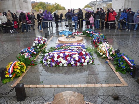
The largest wreath is always laid by the French president. The ribbon below reads “Le Président de la République.”
I don’t make it to the Remembrance Day ceremonies here in Vancouver every year, but every year I do proudly wear my poppy, even though, it seems, that simple gesture has become a political one. All I will say on that topic is this: there is nothing political about me being forever grateful to the Canadian soldiers who liberated my mother and her family from the tyranny of Nazi Germany. If not for them, I would not be here today.
For that reason alone, I will never forget.
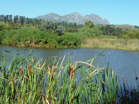
Stellenbosch

If I had any doubts I was on the other side of the world when I arrived in South Africa near winter’s end almost five years ago, they were put to bed 48 hours later after a day of wine tasting. That’s when I discovered how topsy-turvy I was ― in South Africa, grape harvest takes place between February and April.

South Africa’s first vineyards were planted some 350 years ago by French Huguenots who brought vine cuttings with them from France. As of last year, the country is ranked seventh in the world by volume of wine produced. (Canada isn’t even in the top 30.)
It hasn’t been an easy ride to seventh place, however. The economic sanctions against South Africa during the apartheid regime nearly destroyed its wine industry and are still having an impact. Many producers sold their grapes to cooperatives that produced poorly blended bulk wine ― what became known as “supermarket wine.” The practice continued for several years after sanctions were lifted so that, even today, some 20 years later, the country is still trying to shed its reputation as a producer of plonk.
Like the BC winemakers after the FTA and NAFTA, South African winemakers knew they had to start over. They ripped out their vines and replanted to improve the quality of their grapes. Nowadays, these winemakers talk about their industry as having two eras: before Mandela and after.
Stellenbosch is one of three wine regions in the Western Cape wine region of South Africa. Its Mediterranean-like climate, with hot dry summers and cool wet winters, is well-suited for growing grapes, the most popular of which is Chenin blanc. Evidence of how far the region has come since apartheid: at the 2014 Decanter World Wine Awards, Stellenbosch wineries earned 181 medals, of which two were international trophies, one was a regional trophy, and two were gold medals.
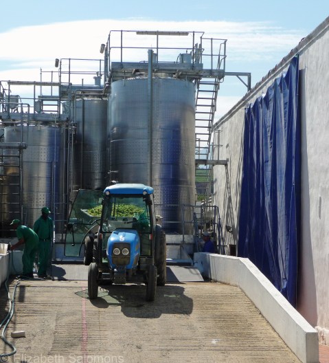
Immediately prior to my arrival in South Africa, I’d spent three months in France, imbibing in, well, let’s just say, a lot of French wine. Even so, I was extremely impressed by the wine I tasted in South Africa and was surprised by the number of vineyards we drove past during our day-long wine-tasting tour through Stellenbosch.

The first winery we stopped at was Meerlust. Established in 1756, it is one of South Africa’s oldest wineries and has been in the same family for eight generations. It is also of the few wineries that maintained its production of fine wine throughout the apartheid regime, despite the lack of access to world markets.
Bilton was our next stop, and we paid a little extra to pair our wine tasting with chocolate. After the tasting, we had lunch ― most of the wineries also have a restaurant on-site ― and I enjoyed my first taste of bobotie. A curried meatloaf with a custard-like topping, bobotie is to South Africa what poutine is to Canada.


Next was Warwick Estates, which dates back to 1771. In the 1970s, a South African and his Canadian wife ― a former ski instructor from Alberta ― worked hard to transform the farm into a winery of some distinction. That ski instructor, Norma Ratcliffe, is still making wine and is the only female member of the Cape Winemakers Guild. Today, Warwick Estates is considered one of the best wineries in the world, known for its Bordeaux-style blends regularly served at South African state dinners. Sadly, the wine is not available in Canada, despite the estate’s best efforts to crack the nut that is our country’s government-controlled liquor boards.


L’Avenir was our last stop of the day, its name a tribute to the French Huguenot heritage of the region. Along with Warwick, it was the prettiest winery we visited.
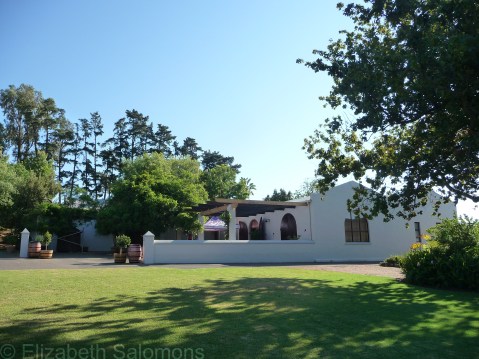
Stellenbosch is rimmed by mountains, and its landscape reminded me of BC’s Okanagan. The distinctive design of the Cape Dutch architecture, with its white, rounded gables, set the place apart from any other wine region I’ve visited, however.
After returning to Canada, I told my local wine seller that I was seriously disappointed with the selection of South African wine in Vancouver, at which point I was told, “there’s no market for it.”
And so, since then, I’ve been on a one-woman mission to create some demand for South African wine in this country.
The Okanagan

When I was growing up in Edmonton, I knew the Okanagan as the place where Albertans headed to every summer in droves. It was considered the perfect family vacation destination by the parents of my school friends, who went there every summer and came back with stories of long days spent swimming and boating in lakes. (My family went to the mountains instead ― a choice my parents made that I personally had no issues with.)
Nowadays, the Okanagan is still a popular summer lake district, but that dry, sunny, Mediterranean-like climate that makes it so popular with boaters and swimmers is also what makes the region perfectly suited to growing grapes.
Those grapes get harvested in the fall, and this year the Okanagan had a bumper crop. While setting a record for the earliest start of harvest ever (August 12) ― thanks to a hot and dry spring and summer ― this year’s grapes were smaller than usual. That’s not necessarily a bad thing. Smaller grapes mean less product, but it can also mean a higher quality wine because the flavour and colour is concentrated.
Fall is also wine festival time. If you happened to be in the Okanagan earlier this month, you could have participated in some of the 125 events that make up the Fall Okanagan Wine Festival with 20,000 of your closest wine-loving friends. This year was the festival’s 35th anniversary.
Yup. That’s 35 years of wine festivalling. But it might surprise you to learn that the tradition of winemaking in the Okanagan goes back to before the birth of Canada. The first person to plant grapes in the Okanagan was Father Charles Pandosy, a Catholic missionary who came to the area in 1859. He needed wine, as all priests do, to be able to administer Mass, and so he planted himself a vineyard.
The first commercial winery ― Calona Vineyards ― was established in Kelowna in 1932 and is still in business. In 1968, Nk’Mip (in-ka-meep) Cellars was established in Osoyoos. Fourteen years later, there were 14 wineries operating in the Okanagan.
And the quality of Okanagan wine back in the 1980s? Well, let’s be generous and call it plonk.
Then along came free trade. It turns out that the Free Trade Agreement of 1988 was the best thing to happen to BC’s wine industry. After losing their preferred status in BC liquor stores, Okanagan winemakers knew they had to improve their product ― fast ― if they were going to complete on the world stage of vintners. So what did they do? They pulled up two-thirds of their vines and replanted with vines that produced better quality grapes suitable for making premium quality wine.

And here’s the amazing thing: the BC winemaking industry exploded. There were 17 wineries in 1990; by 1994, that number had doubled. It doubled again by 2000 and again by 2008. As of last year, there were 254 wineries in operation in the Okanagan with 10,259 acres of vines planted. (To be honest, the rapid expansion of vineyards is beginning to threaten BC’s fruit industry because long-time fruit growers are pulling up their orchards to plant vines. They know they can earn far more from growing grapes than they can from growing peaches and cherries.)
The awards started pouring in early on. The first big one was the 1994 Avery Trophy for Best Chardonnay in the World at London’s International Wine and Spirit Competition, awarded to Kelowna’s Mission Hill Winery. At the 2014 Decanter World Wine Awards (the world’s biggest competition with over 15,000 wines entered in 2014), Okanagan wineries took home 105 medals, including three regional trophies and four gold medals. (By comparison, Californian wineries took home 83 medals that year, none of which were trophies or gold medals.)
Okanagan wines are rather pricey ― some would argue overpriced ― for what you get. But here’s what I’ve learned: those high prices are due to the cost of labour and land. BC vineyard land is the most expensive in the world after Europe. And so, here’s a pro-tip: if you are on a budget, stick to the older Okanagan wineries for more affordable wines. They aren’t cheaper because the wines are lower quality ― they’re cheaper because those wineries bought land back in the 1990s before it got crazy expensive. Their overhead is much lower.
The Okanagan is divided into five subregions: Kelowna, Naramata Bench, Okanagan Falls, Golden Mile, and Black Sage Bench/Osoyoos. I made it to four of these subregions last summer on my way home from Alberta. Here’s a look at some of the wineries I got to. (Click on the first photo at top left to open up the slide show.)


In all, I visited nine wineries and did seven tastings over two days, starting in Osoyoos and finishing 120 km to the north in West Kelowna. I didn’t bother doing a tasting at either Quail’s Gate or Mission Hill ― their wines are readily available in Vancouver, and both tasting rooms, though impressive, were a bit of a zoo. I expected that, because the larger wineries attract the largest crowds, but I stopped at them anyways because I’d been told both were impressive operations and worth a look-see.
But here’s another pro-tip: the best wine-tasting experiences are to be had at the smallest of wineries. Serendipity, for example, is a place that holds up to its name. The tasting room is simple and unpretentious ― a cordoned-off end of a storage shed ― but I had the complete and undivided attention of the wine seller. That experience was wine-buying at its most fun.
Another winery worth a stop is Pentâge Winery on the Naramata Bench. I stopped here on the recommendation of my brother, who claimed it made the best Cabernet Franc he’d ever tasted. A stop at this winery involves a long, windy drive up the side of the mountain, and then a long, steep, windy ride down the side of the mountain that probably scares off timid and cautious drivers. In fact, the winemaker admitted that some visitors won’t even attempt the driveway and instead park their car up top and walk down. I found the tasting room at Pentâge a most pleasant oasis and, knowing it was going to be my last stop of the day, I took my time and chatted with the winemaker for a long while. That stop was the highlight of my two days of wine tasting. (Sadly, my camera was acting up and all my photos are out of focus.)
I won’t have the ways and means to do an Okanagan trip every summer, but I do know this: my wine-buying trip of this past summer has certainly opened my eyes to the best way to buy wine.
American Wigeon

This handsome fellow is an American Wigeon ― another water fowl that is already settled in for the winter at Stanley Park. The male ducks are identified by their white foreheads and the patch of green behind the eyes. I see these dabbling ducks most often in Lost Lagoon, but have also noticed them foraging close to the seawall in both English Bay and Burrard Inlet.
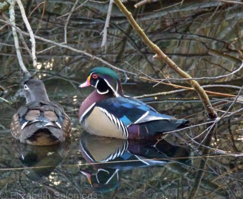
Wood Duck

A couple of years ago when I wasn’t working much and had time to spare, I helped my brother out by taking his one-year-old daughter for the day every couple of weeks or so. My home isn’t set up for napping toddlers and so, after lunch, we’d go for a long walk in her stroller. We both got some fresh air, and she got a decent nap.
Invariably on those afternoons, I took my niece to Lost Lagoon to see the ducks. That’s when I first noticed the incredible variety of duck species in Stanley Park ― something I had never paid attention to before. At the time, I thought it was due to the spring migration.
Fast forward a couple of years to my Florida holiday, which is when I first began to think there might be something to this birding business. I mean, hey, birding involves three things I absolutely adore: the outdoors, photography, and (oh yeah, baby) lists.
After that Florida trip, I began to pay more attention to the birds in Stanley Park. I discovered that English Bay and Burrard Inlet (aka my backyard) is an IBA (Important Bird Area). I also discovered that the ducks I noticed during the long walks with my niece weren’t in the midst of their spring migration, but actually spend the entire winter in Stanley Park.
In short: the best time to go birding in Vancouver is during the winter months.
And so, another sign that fall is well and truly here is the return of our wintering water fowl to Stanley Park. I saw my first Wood Duck of the season last week when I was ambling around Beaver Lake.
Of all the ducks that spend their winters in Stanley Park, the Wood Duck is the prettiest of them all, thanks to its vibrant colours and markings. Unlike most ducks, Wood Ducks like to hang out near wooded areas, which is why the best place to spot them in the park is along the brushy perimeters of Beaver Lake and Lost Lagoon.
I don’t take my niece to see the ducks at Lost Lagoon anymore; she outgrew her stroller, no longer needs a nap, and now lives in another province. But here’s a pro-tip from a novice birder: if you have the chance to explore Lost Lagoon during the winter, grab it. You’ll have it all to yourself, except for, you know, the other birders.
