
Through My Lens: Snowy Rocks on the Beach

Typically, in February I am posting photos of crocuses. Instead, here’s a photo I took this morning of the snow-covered rocks along the beach at English Bay.
Which means it’s not a typical February. (Although … come to think of it, last year’s February wasn’t so typical either.)
Vancouver got dumped with about 25 centimetres of snow yesterday and last night. It’s not an unusual amount of snow for us — we often have one, maybe two good snowstorms every winter — but what is unusual is to get so much snow so late in the season. It’s almost March, folks.
The crocuses, I assure you, are in full bloom, but are well buried today. And tonight’s forecast is for rain, so tomorrow is going to be an unholy muddy mess.
Through My Lens: Noorderkerk

Last summer was about a lot of things, but one thing I made sure to do was take lots of photos of the dozen or so European churches I was able to visit. And now that it’s once again the Season of Lent, I am so happy I get to share those photos with you.
For today, the First Sunday of Lent, here is a photo of the Noorderkerk. (Noorderkerk is Dutch for “northern church”). This church was built in the early 1620s in the Jordaan neighbourhood, right on the Prinsengracht, the outermost canal of Amsterdam’s Canal Belt. The Jordaan was growing fast at the time, and its residents were in need of another place of worship.
The Noorderkerk was purpose-built as a Protestant church (unlike older church buildings throughout the Netherlands that were originally Catholic, but were transformed into Protestant churches after the Reformation.) As such, its shape looks quite different from the traditional long nave of a Catholic church. It was instead built in the shape of the Greek cross, with four naves of equal length, and a small tower at the centre. The idea was that the building was centred around the pulpit, a type of church design that eventually become quite common throughout Calvinist Holland.
I have a lot of affection for the Noorderkerk as it was only a ten-minute walk from where I was living, and I passed it regularly, often daily, on my walks around Amsterdam. To my regret, I didn’t have a chance to see it on the inside — the church is still in use as a congregation and the hours it is open to the public are limited. But though it might look like a quiet, sleepy church, there was always a lot going on outside. On the square surrounding the church are the twice-weekly markets: a flea market on Mondays and a food market on Saturdays. There is nothing like a weekly market to give a church square a sense of being the heart of the neighbourhood.
Which to my mind is kinda cool.
Through My Lens: Winter Hay Bales
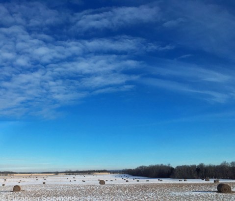
It actually doesn’t matter how I get around in Canada — the view is always spectacular. I took this from the Greyhound last week. It’s somewhere near Ponoka along Highway 2.
The Netherlands by Train
I had lunch last month with a couple of friends who were in town for the holidays. One of them grew up not far from where I was living last summer, and naturally our conversation turned to my summer in Amsterdam. We had a very nice discussion about the differences between the Netherlands and North America. Our topics? The weather, table service, and, erm, the bike culture.
I looked out the window for a moment, thinking about what else I had noticed about life in Amsterdam, and then turned back to face my Dutch-born friend.
“You know what the Dutch do really well?” I said. “Trains.” I then marvelled aloud that I was able to travel by train from Amsterdam to another town for lunch, to yet a different town for dinner, and still be back in Amsterdam by midnight.
Yes, the Dutch have an excellent and comprehensive train system. What do I mean by “comprehensive”? I mean there are 3000 kilometres of railway in a country that is scarcely 400 kilometres from one end to the other. Along that rail network are nearly 400 train stations. That’s right: 400. Few Dutch towns are without a train station.
That kind of rail network isn’t possible in a country like Canada, of course, thanks to the fact that we “have too much geography.” I know that. Yet I still couldn’t help but wonder the other week, as I schlepped by Greyhound from Calgary to Red Deer to Edmonton, how much more pleasant my journey would have been by high-speed train.
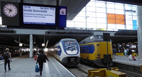
Discovering the Netherlands by train was one of the highlights of my summer and I had lots of fun photographing the dozen or so Dutch trains stations I travelled through.
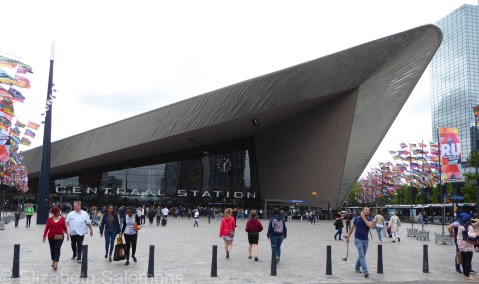
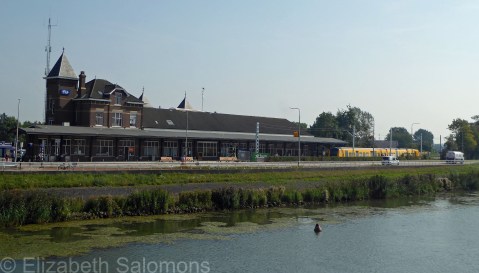
I don’t have a photo of the station I used most often (that would be Amsterdam Centraal) because the building was enshrouded in scaffolding all summer long. But here’s a look at the imposing entrance to Rotterdam Centraal, a station that was rebuilt only five years ago and, like Amsterdam, is one of the country’s busiest rail stations.
Den Haag Centraal is another of the country’s busiest stations. Note the Mondrian windows at the top right.
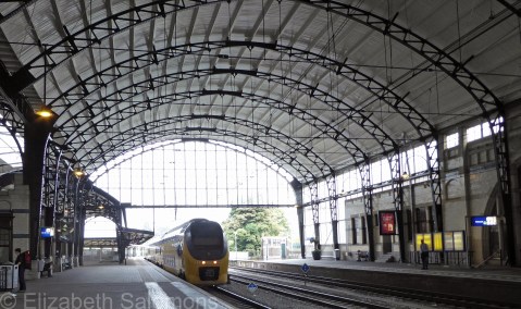
This is Leiden Centraal, another spectacularly designed station.

Most of Holland’s train stations date back to the nineteenth century, however, like this one in Kampen. It’s one of Holland’s smallest train stations. Only one train stops here, a small two-car train that does the ten-minute journey between Kampen and Zwolle three times an hour.
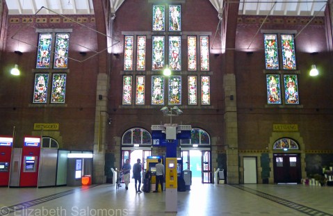
This is the entrance hall to the Maastricht station. See those ticket machines? There’s one for each national rail service: Belgium, Germany, and Holland. How efficient (and multinational) is that?
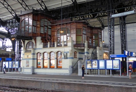
And this photo is from one of my favourite stations: Haarlem. Haarlem is on the Amsterdam–Rotterdam route, the oldest railway line in the country. The current building was built in the Art Nouveau style between 1906 and 1908 and is a national heritage site.
The sign above this doorway reads “Waiting Room First Class.”

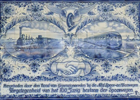
I was especially intrigued by this plaque in Delfts Blauw tile on one of the walls in the Haarlem station. It’s from 1939 and commemorates 100 years of Dutch rail service. Train buffs know that the 1840s were the tech boom of the nineteenth century — railway lines were being laid down all over the place. In Canada, too.
I don’t know how many kilometres of rail travel I did last summer, but I do know this: it is such a civilized way to travel and I loved it.
Through My Lens: Geese on Lost Lagoon
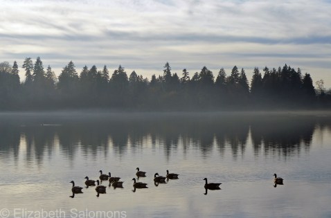
I have nothing to say about this photo, except that when I took it this afternoon, I was having another one of my “I can’t believe I get to live here” moments.
Canada 150: Cape Breton Island
Here we are … finally!
It’s the last day of the year and the last day of the Canada 150 celebrations. (Although, because of the extreme cold weather alert in our nation’s capital, many of the outdoor festivities that were supposed to take place tonight in Ottawa to celebrate both New Year’s Eve and Canada 150 had to be cancelled. Only in Canada, eh?)
For my last post of 2017 and the last post of my Canada 150 series, I am sharing a photo I took along the fog-enshrouded Cabot Trail on Cape Breton Island.
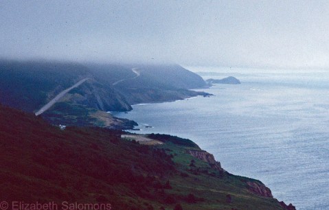
The Cabot Trail is 300 kilometres of winding highway that takes you through the Cape Breton Highlands. It’s named after John Cabot, the Italian explorer who bumped into Cape Breton (or maybe Newfoundland — no one knows for sure) while he was out looking for China way back in 1497.
Stunning scenery, isn’t it? The photo hardly does it justice.
I’ve been thinking a lot about Canada 150, and the year 2017 overall. That’s what we tend to do as the year winds down. What worries me is how smug we Canadians seem to be about ourselves at the moment. It’s easy to be smug, given everything that is going on in the Land of the Free and the Home of the Brave to the south of us. But smugness is a dangerous quality because it leads to complacency. And also the (misguided) belief that what is happening over there could never happen here.
Truth be told, we have no right to be smug. There are some awfully dark chapters in Canada’s history that have been glossed over throughout our Canada 150 celebrations.
On the east coast of Cape Breton Island is the Fortress of Louisbourg National Historic Site. It’s a reconstruction of the military fort built by the French in the eighteenth century, back when Cape Breton was part of New France and called Île Royale. Louisbourg was the first European settlement on Cape Breton and is a stark reminder that Canada’s origins are colonial.
Look up the word “colonize” — there is no way to soften its meaning. It is the process by which one group of people move in and take control of another group of people. And, no matter how many decades or centuries our ancestors have lived here, every Canadian is a colonist and a settler. Think about that when you next sing the national anthem. None of us — except our Indigenous peoples — can claim a “home and native land.”
If that doesn’t wipe away our smugness, I don’t know what will.
Any public event in Vancouver now begins with the acknowledgement that the land we are gathered on is the unceded territory of the Coast Salish peoples, including the Musqueam, Squamish, and Tsleil-Waututh Nations. I like hearing those words, but I do not want them to become so familiar that I hear them without thinking about what they mean.
Just like our national anthem.
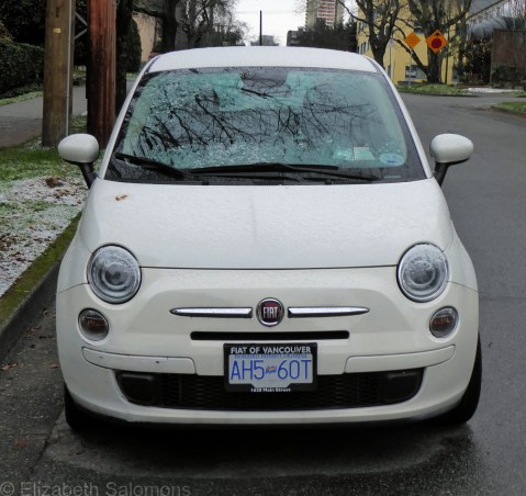
Cinquecento
Here in Vancouver, we woke up to a delightful surprise on Christmas morning: a light dusting of snow. Not enough to create havoc, but enough to call it a white Christmas, something that rarely occurs in Vancouver. (And go ahead and laugh, those of you who live in colder climates. It may not look like much to you, but for us, it was a significant amount.)
I went for a walk to take some photos for the blog and this little Italian car caught my eye. It’s a bit difficult to see the snow because of its colour, but I decided to post the photo anyways, simply because the car is a Fiat 500. And 500 — cinquecento — is a significant number for this post.
Because it’s my 500th blog post.
I had no idea where this blog would take me when I started six years ago, but here I am, still having fun with it. The best part, as much as I enjoy sharing my travel experiences with you all, is how this blog has given me a new lens on my hometown. Wherever I go in Vancouver, whatever I am doing, I now am constantly on the lookout for photos to take or topics to write about that will give someone who has never been to Vancouver a little taste of what life is like here on the Wet Coast of Canada.
That’s because you, my readers, come from all over. WordPress is nice that way in that they tell you these things. This past year alone, I’ve had visitors from 60 different countries.
Going forward, I’m thinking of slowing down somewhat on the frequency and length of my posts. That’s because I have some other projects that need my attention in the coming year, and no big travel plans in my near future.
Then again, who knows? I’ll probably change my mind when (not if) the inspiration hits me.
Merry Christmas!
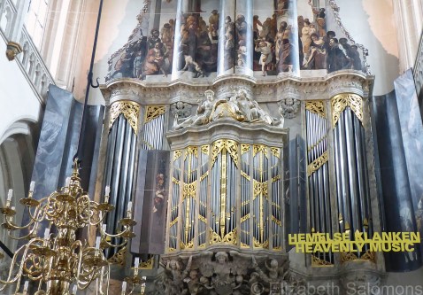
Nieuwe Kerk, Amsterdam
Canada 150: Peggy’s Cove

Oh, look!
It’s the last month of 2017 and I’ve reached the last province on my Canada 150 tour (with apologies to Nunavut and to Newfoundland and Labrador — both are on my bucket list, but I have yet to visit either). I took this photo in Peggy’s Cove, a small community on the coast of Nova Scotia just outside of Halifax.
I’m still on leg two of my cross-Canada road trip. It was a pretty memorable road trip, as far as road trips go, as I was travelling with four siblings and two parental units. Anyone who has ever travelled in large familial groups knows of what I speak.
There were a lot of personal firsts for me on this family vacation, like travelling in convoy (when we were little, we could fit in one vehicle — not so much as adults) and getting up at the crack of dawn so I could photograph an East Coast sunrise. And my first ever lobster, bought fresh off the dock, and cooked on a camp stove.
At this particular point in my family’s history, our respective places of residences were scattered across three provinces, so we were about as pan-Canadian a family as we could be. It was rare for us to be in one place all together, so there were lots of family photos taken, to the delight of some and the annoyance of others, including a whole whack on the rocks at Peggy’s Cove.
Peggy’s Cove is a pretty photogenic place to take a family photo. It has lots of rocks and some fishing shacks and a picturesque lighthouse.
And lots of tourists. By the busload. It was pretty crazy.
I’m just happy they didn’t get in the way of my photo.
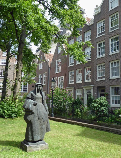
The Begijnhofs
So here’s another cool feature about the Low Countries that I want to share with you.
Those would be the Begijnhofs. Until the eighteenth century, most cities and large towns throughout Holland, Belgium, and northern France had a least one begijnhof. The Beguines (the French word for begijnhof is béguinage) were lay religious orders of the Late Middle Ages and Renaissance. These women were not nuns, and the communities they lived in were not convents. They did not take vows of poverty — some of them had servants. They did not marry while they lived in community, but were free to leave at any time. They supported themselves by teaching or by working as labourers. And they lived in houses surrounded by a walled courtyard (hof is Dutch for “court”). The gates were locked at night, and the community usually included a church and sometimes an infirmary.
One of the reasons these communities came about was simply due to the demographics in Europe at that time: there were more women than men. But also, living in community like this offered these women freedom and independence and choice in how they lived — basic rights that today we all take for granted.
I was introduced to the Amsterdam Begijnhof a long time ago by my Dutch cousin. Amsterdam is full of hofjes, most of which are private, but this one — one of the city’s oldest, dating back to the fourteenth century — is open to the public.
The Begijnhof was allowed to continue to exist as a Catholic institution during Calvinist rule because the homes were private property. The Beguines lost their chapel, however, and today it is the English Reformed Church. Later, they built a “hidden church.” (For the period of time when Catholic churches were banned in Protestant Amsterdam, Catholics built their churches behind the façades of regular houses. From the outside, they look like ordinary houses, but on the inside, they look just like a church.)
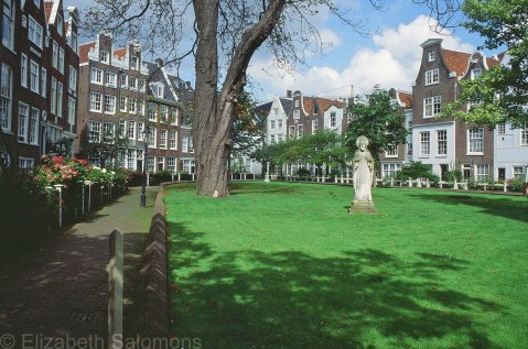
One curious fact about the Begijnhof: it is at medieval street level, which is about a metre below the rest of the city. What I also find particularly curious is how its entrance backs onto the Kalverstraat, one of the city’s busiest shopping streets. The last Beguine died in 1971, but the Begijnhof continues to be occupied by about 100 women.
It was my familiarity with the Amsterdam Begijnhof that led me to explore the ones in Belgium. The Prinselijk Begijnhof Ten Wijngaerde (Princely Beguinage of the Vineyard) is located next to Brugge’s Minnewater. Dating back to the mid-thirteenth century, it is one of the best-preserved begijnhofs in the country. You enter it through this gate.

It contains a church and about 30 white painted houses.

For the last 90 years, it has been the residence of a community of Benedictine nuns.

The Oude Begijnhof in Gent, also built during the mid-thirteenth century, is no longer walled. During the French Revolution, the city acquired property rights to the Begijnhof and then, in the eighteenth century, it wanted to take it over to use as housing for labourers. The Beguines moved to a new purpose-built begijnhof in the suburbs. The houses in the original begijnhof became worn and run-down, but were eventually restored in the twentieth century.

None of the original medieval houses are still standing in any of the begijnhofs throughout Belgium and Holland, although the layout of the communities remains essentially the same. Wooden houses were rebuilt in brick or stone from the sixteenth century onward. An exception is the single wooden house in the Amsterdam Begijnhof (the oldest wooden house in the centre of Amsterdam and one of only two still standing).
What I find fascinating about the begijnhofs is the witness they bear to a long tradition of women living independently in times when few were permitted to do so. As communities, they developed an architectural style of their own, which fortunately has been preserved.
And for the tourist overwhelmed by the chaos of central Amsterdam or on a whistle-stop tour of Belgium, they are a welcome oasis from the hustle and bustle of a tourist-overrun city.
